News
‹ back to weather news
News
-
When will Melbourne's warm dry spell end?
Anthony Sharwood, 13 May 2025When the mercury passed the 20-degree mark in Melbourne early this Tuesday afternoon, it marked the ninth time in 13 days that Melbourne’s temperature had reached 20°C or higher this month.
Melbourne's May 2025 maximums are currently running at around 4.4°C above the monthly average of 16.8°C, and while you expect the start of May to be warmer on average than the end of the month, that’s still a significant anomaly.
Melbourne has also received just 1.2mm of rainfall this month. The dry start to May follows three below-average rainfall months, including a very dry April with just 19.2mm in total.
Much like Perth and Adelaide, Melbourne’s weather in recent weeks has been more reminiscent of early autumn than late autumn.
So when are things going to change?
There are two answers to that question.
In the short term, an influx of colder air is due this weekend, with showers on Saturday with a maximum around 15°C, then a clearing shower on Sunday as the high edges up to 16°C or so.
The weekend system will not be particularly vigorous, with the cold front passing through Tasmania only clipping southern Victoria. But it will still be cool enough to make the air feel more like 12 or 13 degrees at the MCG on Saturday afternoon, where Collingwood takes on Adelaide.
Over the medium and long term, there’s no current indication of a switch to persistent chilly, showery weather – even though winter is now less than three weeks away.
Next week, Melbourne temperatures again look likely to edge up towards 20°C under mostly clear skies, as yet another stubborn, blocking high pressure system dominates Australia’s weather.
As Weatherzone reported last week, these persistent highs have caused parts of South Australia, Victoria and Tasmania to endure their driest start to a year on record.
The highs are linked to a predominantly positive Southern Annular Mode (SAM) – which means that the band of storm-bearing westerlies has contracted towards the pole, with substantial rainfall blocked from reaching the southern mainland by the highs.
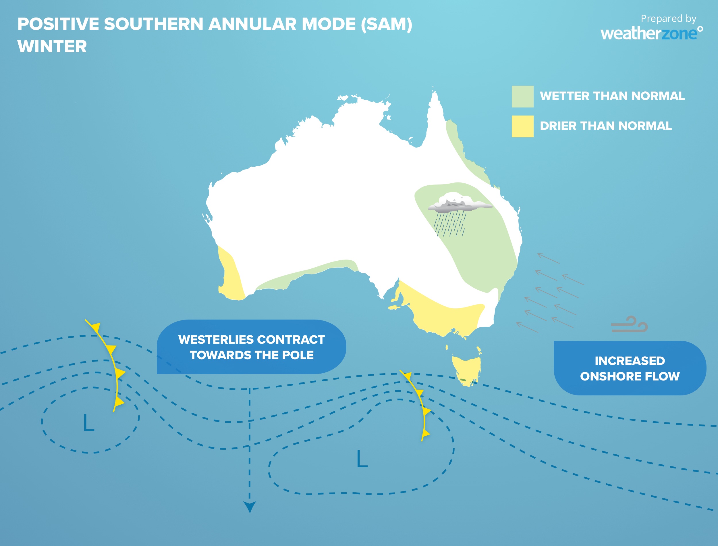
Image: Diagram of the typical effects of a positive Southern Annular Mode in winter.
By contrast, Sydney and parts of eastern NSW have been wet. Indeed, Sydney has seen rain on 11 of the first 13 days of May, on the back of a nine-day rainy streak to end April.
As the light green blob on the diagram above shows, that is a classic pattern for a positive SAM in late autumn or winter.
READ MORE: What is the SAM and how does it affect Australia?
Meanwhile the BoM’s latest long-range forecast overview – issued on May 8 for the period from June to August – predicts that:
- Rainfall is expected to be in the typical range for much of Australia.
- Warmer than average days are very likely across Australia.
- Warmer than average nights are very likely across Australia.
If you're a Melburnian who’s enjoying the relatively mild late autumn, expect similar conditions next week and possibly for several more weeks.
But if you're a rain lover or a snow lover who depends on strong winter cold fronts to get your wintry fix, it might pay to start doing a snow dance ahead of the official King's Birthday season opening on June 7.
- Other news
- Tue 13 May 2025 Outback Queensland bursting with green
- Mon 12 May 2025 Tropical lows, heavy rainfall and earthquakes impacting Indonesia and the South Pacific
- Mon 12 May 2025 Perth's absurd May warmth to continue this week
- Sun 11 May 2025 Wet week ahead for east coast
- Sat 10 May 2025 Brisbane's coldest May evenings in two years