News
‹ back to weather news
News
-
Hurricane Katrina, 20 years on
Stephen Davenport, 22 August 2025August marks the 20th anniversary of the costliest hurricane to hit the USA. Hurricane Katrina made landfall in Louisiana on August 29th, and subsequently caused an estimated $125 billion of damage and around 1,200 fatalities.
Birth and development
On August 23rd, a tropical depression developed over the southeastern Bahamas, attaining tropical storm strength as it crossed the central Bahamas on the 24th, when it was named Katrina. Ahead of its first landfall in southeastern Florida, Katrina gradually intensified to a Category 1 hurricane on the Saffir-Simpson scale, with sustained wind speeds up to 80mph.
Growth in the Gulf
While crossing southern Florida and taking a temporary left turn to the southwest, Katrina briefly weakened; but it then passed into the Gulf, where very warm waters turbo-charged its development.
By August 28th, Katrina had grown into a huge and intense hurricane, reaching Category 5, with sustained winds of up 175mph at their peak. Meanwhile, it had taken a turn northwesterly then eventually northerly, with its center aiming squarely at southeast Louisiana.
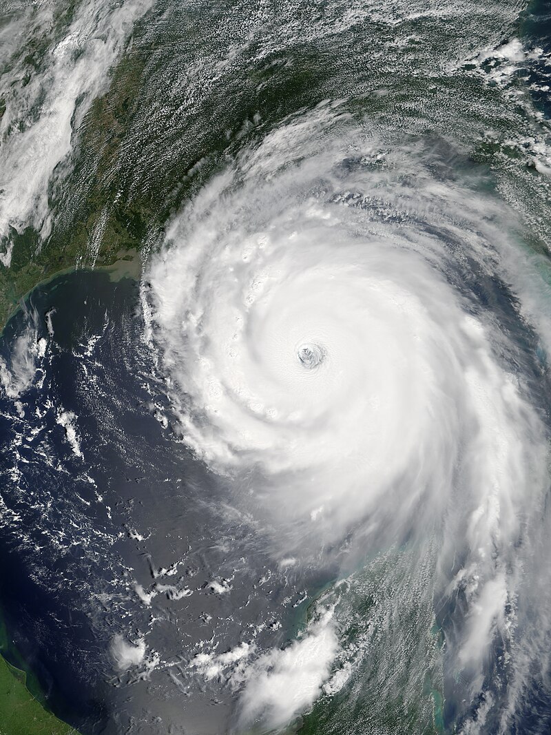
Image: Visible satellite image of Hurricane Katrina over the Gulf on August 28, 2005.
Katrina made its second landfall here pre-dawn on August 29th, and although losing some strength it still moved across the coast as a Category 3 hurricane with sustained winds of 125 mph. Mississippi was next in line as the storm moved farther north, and Katrina only weakened below hurricane strength as it moved inland into central-eastern Mississippi, although it was still classed as a hurricane. Katrina’s lowest central pressure was 902hPa, and it was 920hPa at landfall, the third lowest in US history for a landfalling Atlantic hurricane.
Storm surge
One of the most significant features of Katrina was its storm surge, which comes about when extreme winds push ocean water towards and across the coast, with shallower coastal slopes (such as found along the Louisiana coastline) creating higher surges than areas where coastal waters drop more sharply. The popular conception is that low pressure allows an upwards ‘bulge’ of water, but this is very minimal in comparison. The surge was measured at 25 to 28 ft above normal tide level along portions of the Mississippi coast, and 10-20 ft across the coast of southeast Louisiana.
Impacts and aftermath
On top of all that, southern Florida saw 10 to 14 inches of heavy rain, while 8 to 12 inches fell along the Gulf Coast and some way inland. Heavy rain affected the western Tennessee Valley and the Ohio Valley as Katrina continued north-northeastwards and weakened to a tropical depression, only eventually losing its identity near Indiana, Ohio and the eastern Great Lakes. The storm also spawned 33 reported tornadoes.
Katrina was such a massive hurricane that its impacts spread farther afield, significantly affecting the Florida Panhandle and Alabama as well. However, the most devastating destruction was felt in the New Orleans area, where at least 80% of the city was flooded by the end of August, in part due to failure of levees between New Orleans and Lake Pontchartrain.
Southeastern Louisiana and southern Mississippi suffered catastrophic damage from winds and storm surge, extending a few miles inland, with many coastal structures destroyed along the Mississippi coast and parts of southeastern Louisiana.
Vulnerability
According to the National Weather Service, much of the Gulf Coast coastline is less than 10 feet above mean sea level, so storm surges even with less powerful systems will always be a threat. Over half of the USA’s economic productivity is located within coastal zones. Moreover, large and powerful storms like Katrina can interrupt shipping, especially in and out of ports, and pause productivity in the Gulf’s oil fields.
2025 hurricane outlook
Although 2025 has been rather quiet so far in the North Atlantic basin and the Gulf, with just five tropical storms so far, Hurricane Erin being the most recent. Erin, fortunately, passed east of the Carolinas on a re-curving north then northeastward track.
We are heading towards the climatological peak of the hurricane season, which occurs in September, and with wind shear over the Atlantic decreasing, there are further signs of activity through at least the next couple of weeks.
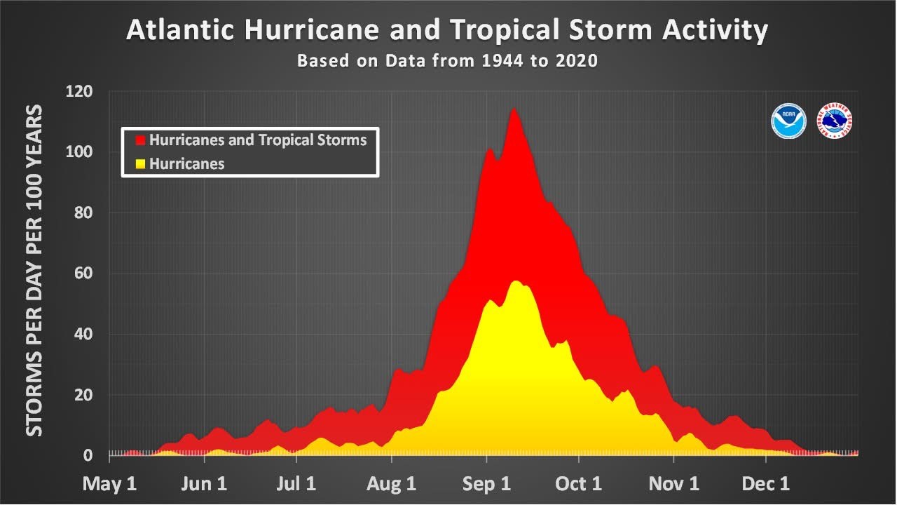
Image: Atlantic hurricane climatology. Source: NOAA
Exactly where any future systems might track is unknown this far ahead but just now it looks like there are equal chances of further systems re-curving near or east of the Atlantic coast or tracking more westwards into the Gulf – or indeed spawning there.
It’s impossible to say whether or not we will see a hurricane anywhere near as powerful as Katrina this season; but with Gulf of Mexico sea surface temperatures well above normal – on average, in the upper 80s F – there is plenty of fuel on tap.
- Other news
- Fri 22 Aug 2025 Sydney on verge of third wettest August on record
- Fri 22 Aug 2025 Burst of fall temperatures to descend through US this weekend, next week
- Thu 21 Aug 2025 The key factor behind the relentless NSW rain
- Thu 21 Aug 2025 Sydney's wettest August day in almost two decades
- Wed 20 Aug 2025 Relentless NSW rain to intensify before drying trend sets in