News
‹ back to weather news
News
-
Tornado observed near Young, NSW
Anthony Sharwood, 10 September 2025A tornado has been observed near the town of Young on the South West Slopes of New South Wales around 3:30pm on Wednesday afternoon, as severe thunderstorms spread across the state.
The tornado occurred as part of a severe thunderstorm outbreak, with the BoM updating its severe thunderstorm warning shortly afterwards to include a reference to the confirmed tornado.
At 4:40pm (AEST), the BoM’s issued its latest severe thunderstorm warning for parts of the Hunter, Central Tablelands, Southern Tablelands, Central West Slopes and Plains, and South West Slopes forecast districts, warning of the risk of damaging winds, large hail and heavy rain.
A pair of dramatic images of the tornado showing the classic funnel cloud twisting its way to ground level among the golden spring canola fields were captured by the New South Wales Rural Fire Service.
As several storms sweep across NSW this afternoon, there has been a report of a tornado near Young. These images were captured by a #RFS fire tower looking to the northwest of Young. pic.twitter.com/Iv2WkXelck
— NSW RFS (@NSWRFS) September 10, 2025“The storm in which the tornado was embedded could also be seen on the weather radar, where the heaviest areas of rain (the red and yellow areas) just west of Young formed a hook shape which is a sign of a tornadic supercell,” Weatherzone meteorologist Joel Pippard explained.
“In the moments leading up to the tornado, the radar shows a supercell (red shading) just to the east of a line of storms. When the line of storms caught up to the supercell, it disrupted its structure and imparted a rotation on the storm. That created all the ingredients for a funnel cloud to descend to the surface to become a tornado.
"The type of tornado was a rope tornado, Pippard added.
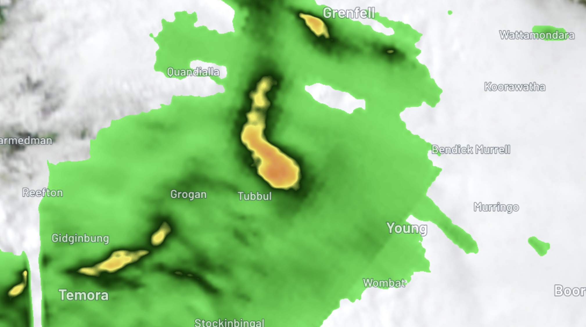
Image: Radar image showing the thunderstorm that produced the tornado near Young, NSW, on Wednesday, September 10, 2025.
The Wednesday afternoon severe thunderstorm outbreak is associated with a low pressure system passing over NSW, integrating with copious atmospheric moisture and atmospheric instability.
This system will continue to cause rain, thunderstorms and potentially damaging winds over parts of NSW into Wednesday night and Thursday. Check the latest severe weather and thunderstorm warnings for the most up-to-date information.
- Other news
- Wed 10 Sep 2025 Wild night of rain, wind and surf coming for Sydney and surrounds
- Tue 09 Sep 2025 Southern Hemisphere's polar vortex is weakening – here's what this means for Australia
- Tue 09 Sep 2025 Vast area of booming outback storms
- Mon 08 Sep 2025 Sydney swelters in 30°C
- Mon 08 Sep 2025 Spring see-saw brings wildly fluctuating temperatures