News
‹ back to weather news
News
-
Northern Australia’s 2024-25 wet season wrap up
Felix Levesque, 9 May 2025Northern Australia’s 2024-25 wet season featured the busiest cyclone season in 19 years, latest monsoon onset on record and intense thunderstorm outbreaks.
The northern Australia (north of 26°S) average wet season rainfall in 2024-25 was 21% above the 1961-1990 average. As seen in the rainfall deciles map below, this above average rainfall was driven by heavy rain events in Western Australia and Queensland.
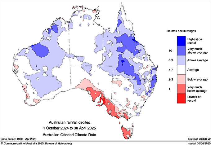
Image: rainfall deciles throughout Australia’s northern wet season. Source: BoM
Early wet seasonal rainfall was mostly average to above average with active thunderstorm outbreaks, especially over the north of Western Australia and the Top End. January, however, saw a respite from the rain as the monsoon failed to arrive, with much of the Northern Territory and Queensland experiencing below average rainfall, as seen in the image below. January also ranked the driest northern Australian January since 1994.
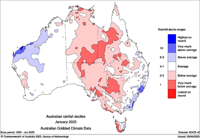
Image: rainfall deciles throughout Australia during January 2025. Source: BoM
Active tropical cyclone activity through the latter half of the season brought further heavy rainfall to Western Australia and Queensland. Overall, 12 tropical cyclones affected the Australian region, the most since the 2005-06 season. Eight of the 12 tropical cyclones were severe (category 3 or greater), including Sean, Taliah, Vince, Zelia, Alfred, Bianca, Courtney and Errol. An estimated insured losses exceeding $1.55 billion AUD, primarily from Zelia and Alfred, made it the most expensive season since the 2017-18 season with Tropical Cyclone Debbie.
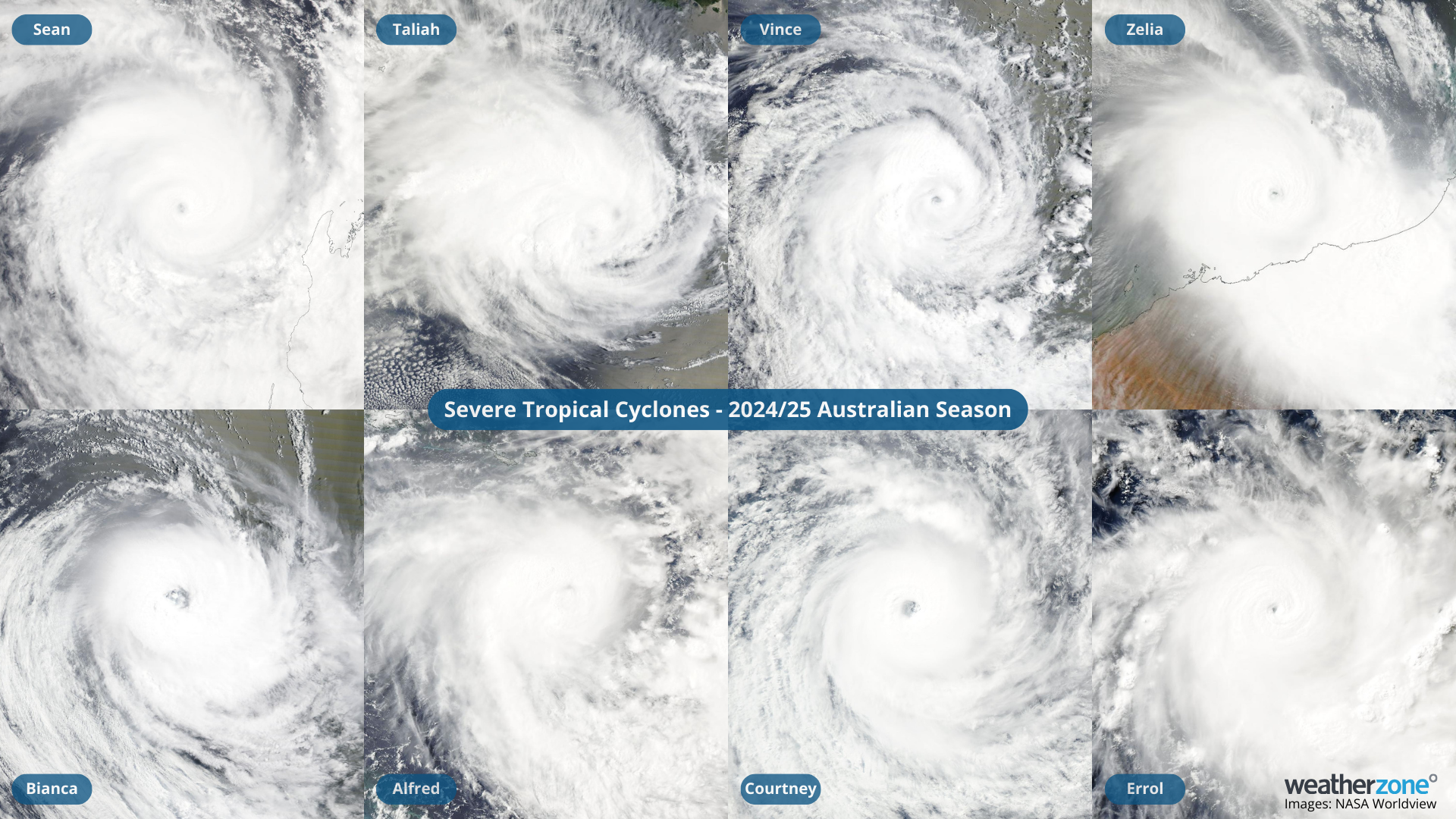
Image: The eight severe tropical cyclones that developed during the 2024-25 season. Source: NASA Worldview
Compared to the 1961-1990 long term average, this northern Australia wet season was also the:
- Warmest on record for mean minimum temperature (averaged 1.67°C above the long term average)
- 5th warmest on record for mean maximum temperature (averaged 1.61°C above the long term average)
- Above average temperatures across most of northern Australia
Western Australia
Heavy rainfall with thunderstorm outbreaks, especially through the early wet season, followed by tropical cyclone activity led to a well above average wet season for Western Australia.
The biggest story to come out of Western Australia’s northern wet season was the huge amount of tropical cyclones to form over the region. 11 of the 12 tropical cyclones to form this 2024-25 season were in the Western Region, the most active season in 41 years for the region. Seven of the tropical cyclones were severe (category 3 or greater), which is the most for the region since 1998-99.
Of the 12 tropical cyclones that formed this season, only four made landfall over the Australian mainland. For Western Australia, Severe Tropical Cyclone Zelia was the most impactful system, crossing the coast as a category 4 tropical cyclone just east of Port Hedland in February. Other significant systems include:
- Tropical Cyclone Dianne crossed the Kimbereley Coast as a category 2 in March.
- Tropical Cyclone Errol crossed the Kimbereley Coast as an ex-tropical cyclone in April.
- Tropical Cyclone Sean also impacted parts of the Pilbara coast, but did not cross the coast as it tracked parallel to the region in January.
Northern Territory
The most notable story to come out of the Northern Territory’s wet season was the latest monsoon onset on record. With records dating back since 1957-58, this season’s onset date of February 7 in Darwin was nearly 2 weeks later than the previous record, which was on January 25, in the 1972-73 season. Typically, the monsoon onset in Darwin is during the last week of December.
The Northern Region, which stretches from the WA-NT border to the tip of Cape York Peninsula, also failed to record a tropical cyclone for the first time since the 2020-21 season.
Even with the late monsoon and lack of tropical cyclone activity, active thunderstorm outbreaks brought near average rainfall for the Northern Territory throughout this past wet season.
Queensland
Rainfall across much of Queensland was well above average during the past wet season as a result of record warm sea surface temperatures, a La Niña like pattern and Tropical Cyclone Alfred.
Read more: Why Queensland has been getting all the rain
Averaged across the state, the wet season rainfall amounted to 711.8mm, making it the 11th wettest wet season on record (since 1900), and wettest since the 2010-11 wet season.
- Other news
- Fri 09 May 2025 Perth heading towards record late season warmth
- Thu 08 May 2025 Here's what Mother Nature has in store for Mother's Day
- Thu 08 May 2025 Snow blankets Tasmania, chill spreads to SE mainland
- Wed 07 May 2025 Record dry start to year in parts of three Australian states
- Wed 07 May 2025 Powerful cold front sweeping across Tasmania