News
‹ back to weather news
News
-
Tropical Cyclone Fina has made initial landfall
Jess Miskelly, 22 November 2025Tropical Cyclone Fina crossed the Cobourg Peninsula overnight as a Category 2 system and is now over the Van Diemen Gulf, heading southwest and strengthening. As of 7.33am Northern Terrtitory time, Fina is a Category 3 Cyclone.

Image: Satellite and radar animation showing the eye of Fina crossing the Cobourg Peninsula late Friday evening.
The nearest weather station to the passing system was Croker Island, a good 30 km or so to the east, which recorded wind gusts of 107km/h and mean wind speeds of 76km/h. In that same location, 189mm of rain fell in the 24 hours to 9am on Fri 21st with another 95mm falling from 9am Friday to 7.30am Saturday. Munganella Airstrip, even further to the east, has picked up 213mm in the 22.5 hours to 7.30am Saturday, most of that falling since 9pm as the cyclone crossed to the west.
Fina has now moved back over the open water of the Van Diemen Gulf between the mainland Northern Territory and the Tiwi Islands, likely bringing gusts of 140km/h to eastern Melville Island this morning, expected to increase to 170-190km/h over the coming few hours. Fina is still forecast to pass very close to Darwin tonight and in the early hours of Sunday morning. Gusts of well over 130km/h are possible for the city, starting as southeasterlies, and turning to northeasterlies with the passage of the system. Heavy rain of 150-300mm in less than 24 hours is also likely, with isolated heavier falls of up to 500mm. Check updating forecasts for Darwin and Tropical Cyclone Fina.
Darwin is no stranger to tropical cyclones, and its strong infrastructure is vastly different from the flimsy buildings that caved under Tropical Cyclone Tracy in 1974. Nevertheless, Fina is a significant weather system, and residents are advised to prepare accordingly, as per the Bureau of Meteorology and Northern Territory Emergency Services guidelines, summarised in the latest Tropical Cyclone Advice. Flying debris as well as falling powerlines and trees are some of the potential hazards.
Bombed by the Japanese in 1942, flattened by Tracy in 1974, Darwin knows how to bounce back. Stay safe.

Image: Current forecast track map for Tropical Cyclone Fina as of 7.33am NT time Saturday 22nd. Source: Bureau of Meteorology
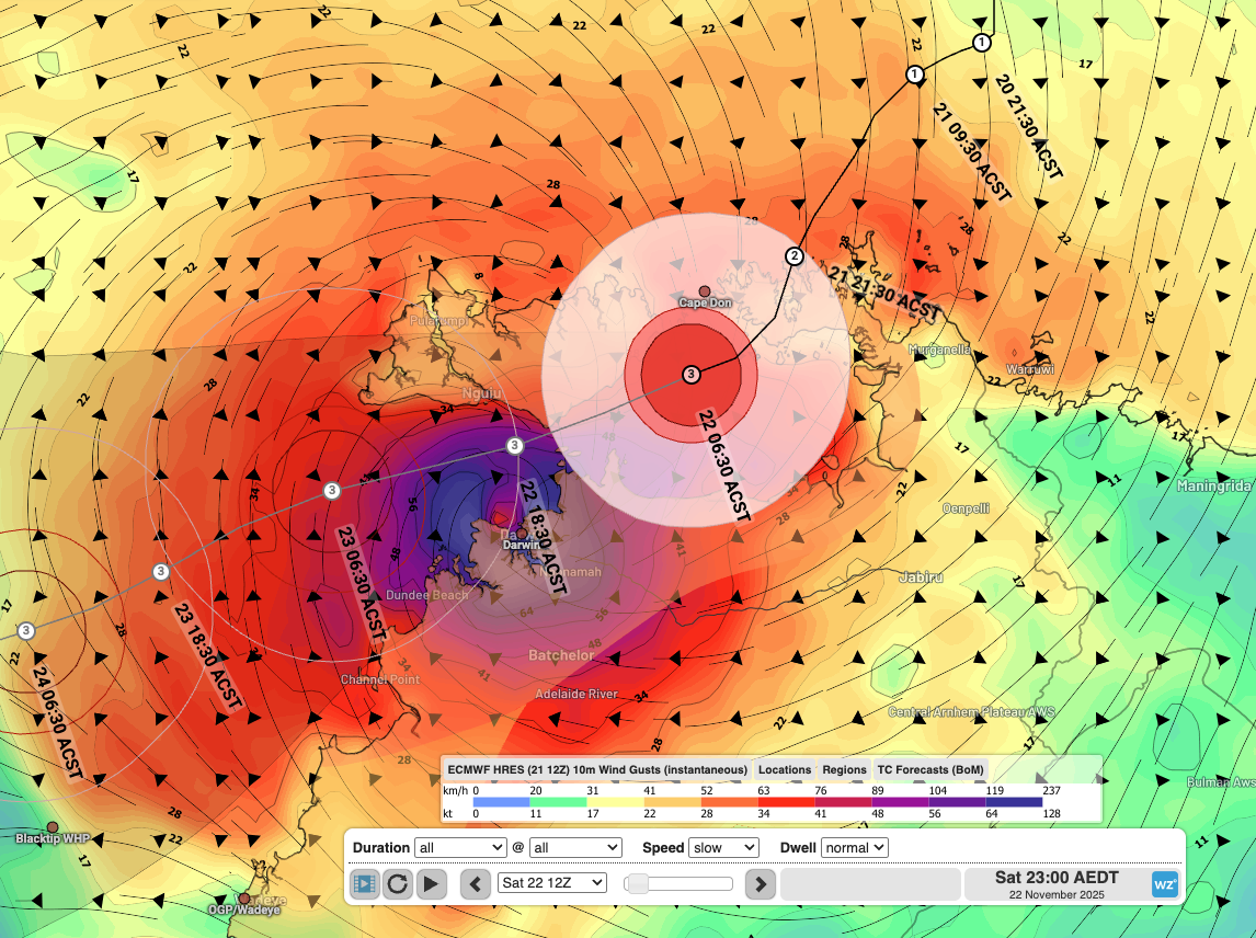
Image: Forecast wind gusts from the ECMWF model for 10.30pm local time Saturday night overlaid with Fina's forecast track according to the Bureau of Meteorology. The ECMWF model has the cyclone deviating slightly southward from the forecast track.
- Other news
- Fri 21 Nov 2025 How a tropical cyclone near Darwin will cause 47C heat over Australia next week
- Fri 21 Nov 2025 Fina could be Australia's first November category 3 cyclone in 20 years
- Thu 20 Nov 2025 Tropical Cyclone Fina to pass near Darwin this weekend – here's what to expect
- Wed 19 Nov 2025 Tropical cyclone north of Australia, polar airmass to the south
- Wed 19 Nov 2025 Tropical Cyclone Fina forms north of Darwin, landfall possible this weekend