News
‹ back to weather news
News
-
Tropical Cyclone Fina to pass near Darwin this weekend – here's what to expect
Ben Domensino, 20 November 2025Tropical Cyclone Fina has turned towards the NT coast and is expected to make landfall over the Top End on Friday. The system could then regain strength over the warm Van Diemen Gulf, before passing close to Darwin on the weekend.
Where is Fina now?
Fina is currently sitting off the north coast of the NT. At 9:30am ACST on Thursday, November 20, Tropical Cyclone Fina was a category two system located roughly 405 kilometres northeast of Darwin. Wind speeds near its core were averaging 95 km/h and gusting to about 130 km/h.
While Fina had been moving towards the east on Wednesday, it took a right-hand turn overnight and has now started to move south, a track that will allow it to approach the NT’s Top End over the next 24 hours.
Where will Fina make landfall?
Fina is expected to pass over the Cobourg Peninsula and Croker Island as a category two tropical cyclone late on Friday, where it will cause heavy rain, damaging to destructive winds and abnormally high tides. Some of this severe weather will also extend to parts of the Tiwi Islands into Saturday morning.
Tropical Cyclone Fina is likely to weaken as it crosses the Cobourg Peninsula on Friday night. However, it should re-intensify on Saturday as it moves over warm water in the Van Diemen Gulf.
Fina is expected to be a category two tropical cyclone as it traverses the Van Diemen Gulf, although there is small chance it could reach category three strength on Saturday as it draws energy from the warm water in the Gulf.
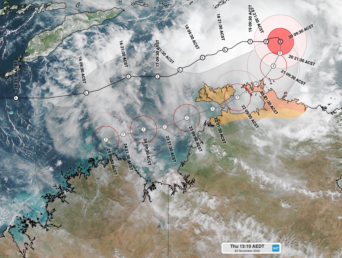
Image: Current satellite image and extended forecast track map for Tropical Cyclone Fina. Valid at 1:10pm AEDT (11:40am ACST) on Thursday, November 20. Source: Weatherzone.
Will Fina hit Darwin?
The current forecast track for Fina shows the system exiting the Van Diemen Gulf and moving through the Clarence Strait on Saturday afternoon, before passing north of Darwin on Saturday night.
While the official forecast track keeps Fina more than 40km to the north of Darwin on Saturday night, some computer models suggest it could move closer to, or even directly over Darwin on the weekend.
It is important to point out that there is notable disagreement between models regarding how close Fina will get to Darwin on the weekend. The two maps below show different predictions for Fina’s position on Saturday night.
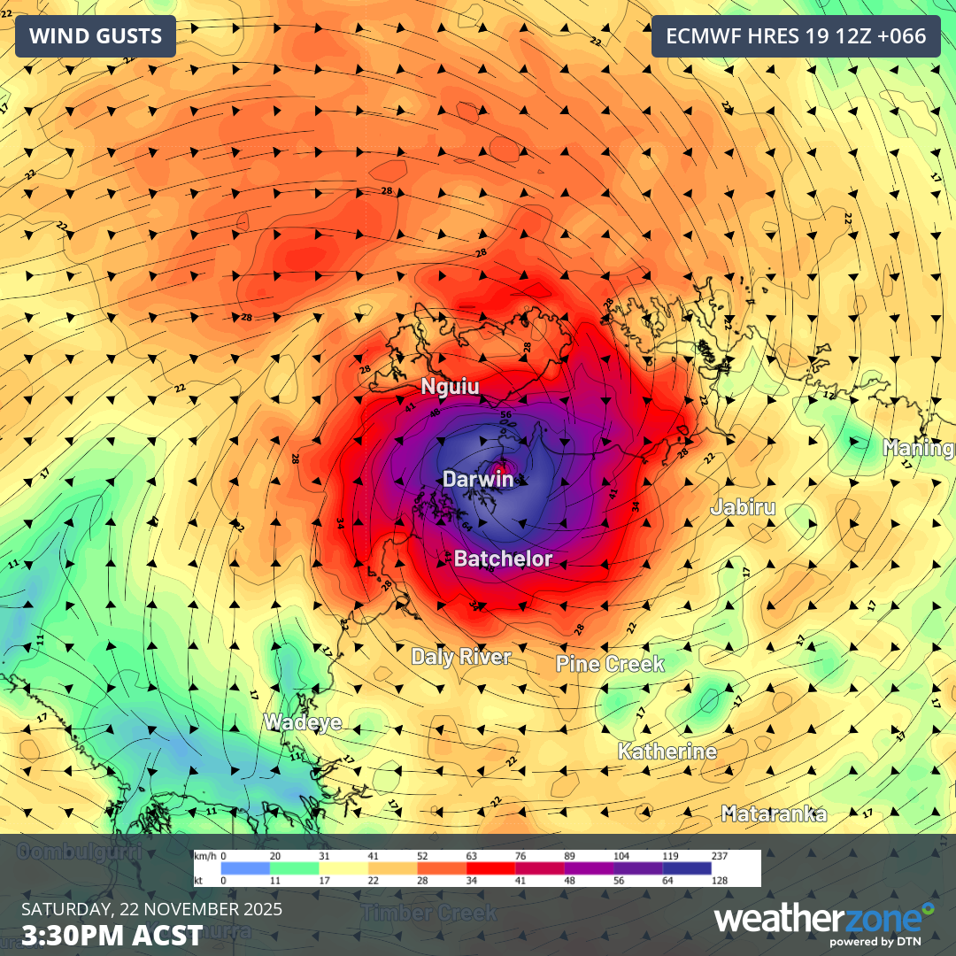
Image: Forecast wind gusts from the ECMWF model showing the eye of Tropical Cyclone Fina directly over Darwin on Saturday afternoon. This is not the official forecast track and should be treated with caution. Source: Weatherzone.
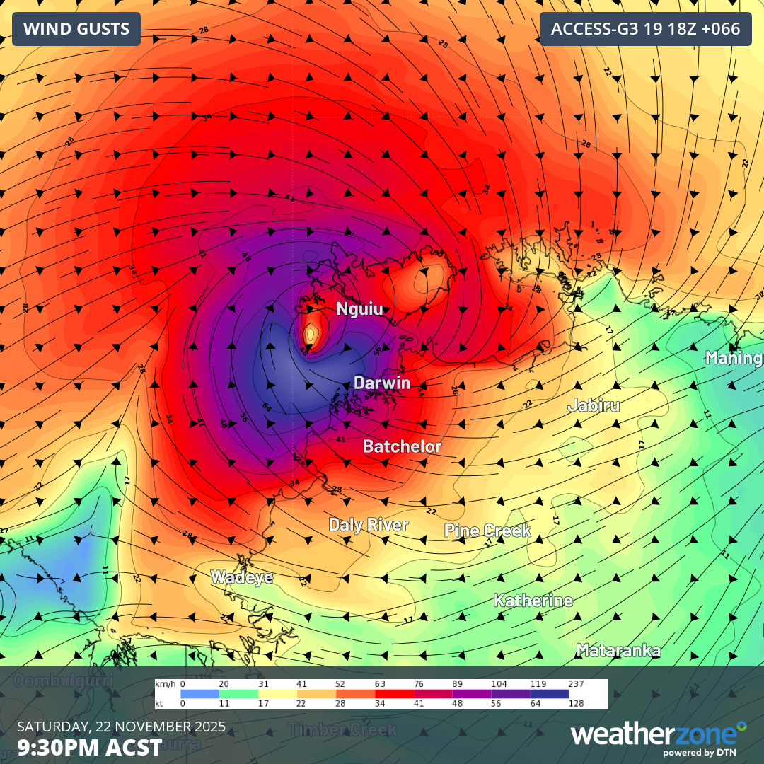
Image: Forecast wind gusts from the ECMWF model showing the eye of Tropical Cyclone Fina directly over Darwin on Saturday night. This is not the official forecast track and should be treated with caution. Source: Weatherzone.
Regardless of exactly how close Fina gets to Darwin, the city and surrounding areas are likely to be impacted by heavy rain and damaging winds on Saturday and Sunday. At this stage, the most intense weather in the Darwin region will occur between Saturday afternoon and Sunday afternoon.
After passing Darwin, Fina is expected to track in a west to southwesterly direction on Sunday and Monday. At this stage, it could approach the northern Kimberley coast for another landfall early next week, causing heavy rain, flooding and damaging to destructive winds.
Rainfall totals from Fina are likely to reach about 100 to 300 mm across a broad area of the northwest Top End, with isolated falls reaching around 500 mm.
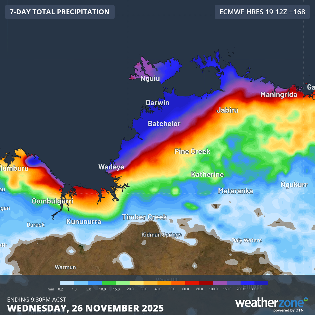
Image: Forecast accumulated rain over the next 7 days, according to the ECMWF model. The darkest blue shading indicates rainfall more than 300mm is expected. Source: Weatherzone.
Wind speeds will depend on the tropical cyclone’s strength over the coming days, with category two tropical cyclones typically causing gusts of 125 to 164 km/h. Category three tropical cyclones can cause wind gusts of about 165 to 224 km/h.
Tropical cyclone warnings, marine wind warnings and flood watches have been issued for parts of the NT. Check the latest warnings in your area for the most up-to-date information on this system.
- Other news
- Wed 19 Nov 2025 Tropical cyclone north of Australia, polar airmass to the south
- Wed 19 Nov 2025 Tropical Cyclone Fina forms north of Darwin, landfall possible this weekend
- Tue 18 Nov 2025 Tropical cyclone risk increasing near northern Australia
- Tue 18 Nov 2025 Perth Ashes Test weather: slight chance of showers on first two days then mostly clear
- Mon 17 Nov 2025 High tropical cyclone risk near Australia this week – rare November landfall possible