News
‹ back to weather news
News
-
Rain, waves and gales smashing eastern NSW
Felix Levesque, 19 May 2025Intense rain, large waves and powerful winds are lashing eastern NSW as a deep low pressure trough lingers near the coast, with a dynamic week ahead.
The satellite loop below shows cloud, rain and thunderstorms streaming over eastern NSW on Monday, focussed on the areas around Newcastle and the Hunter Valley.
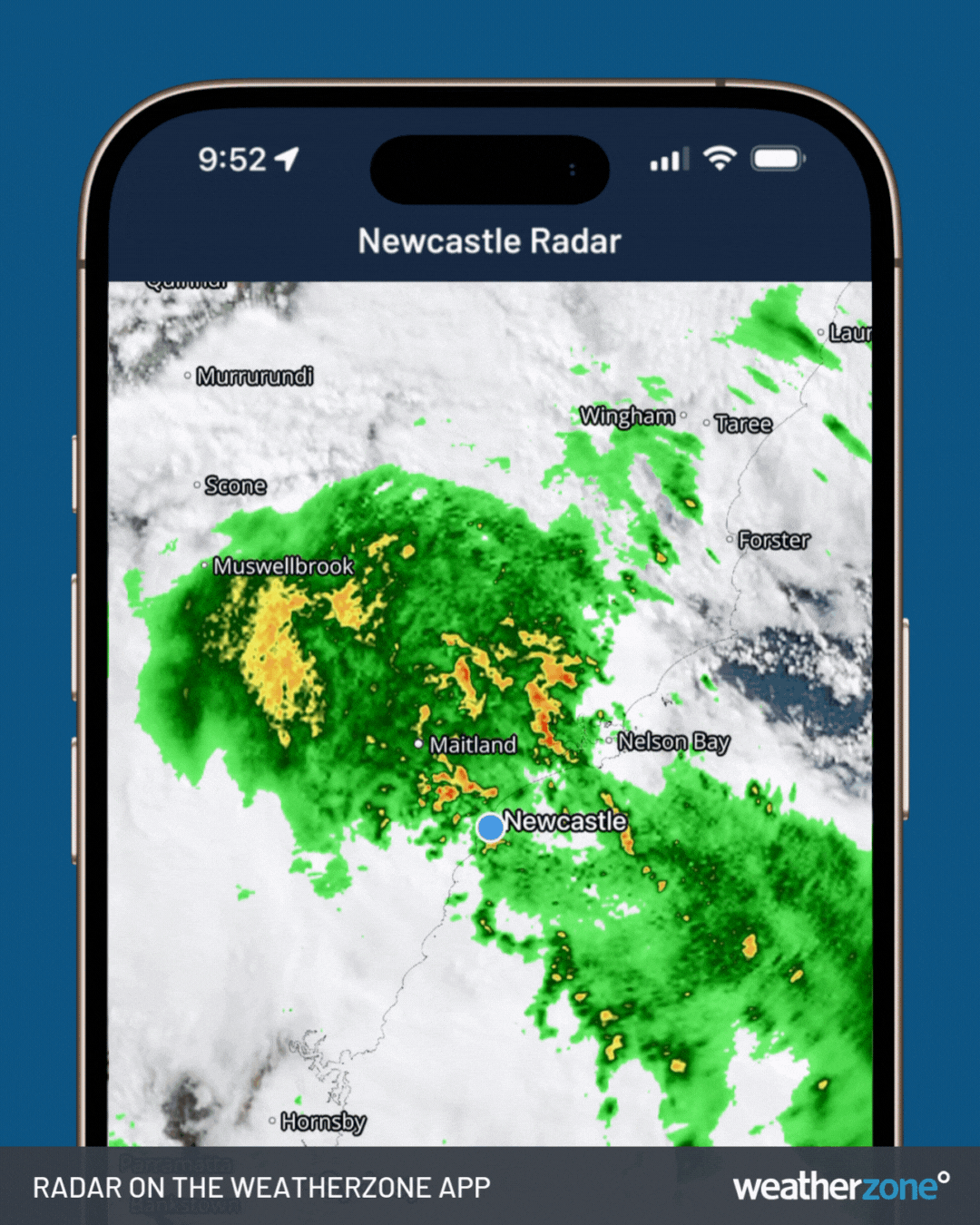
Video: Radar on the Weatherzone app for Newcastle, NSW, featuring cloud (white), rain (green) and lightning (purple).
Extending up into the atmosphere is a pool of cold air over northeastern NSW which is enhancing a deep stream of moist easterly winds coming off the very warm waters of the Tasman Sea. This synoptic situation will remain slow moving through the mid-week period, bringing intense and hazardous weather.
Gales and damaging winds
Overnight into Monday morning, some notable recorded wind gusts over central eastern NSW included:
- 106km/h (sustained 87km/h) at Norah Head
- 102km/h at Wattamolla
- 95km/h at Newcastle Nobby Signal Station
- 85km/h at Kiama and Murrurundi Gap
Strong southeasterly winds will persist over Monday and into Tuesday, with sustained winds reaching 60-80km/h and wind gusts reaching 90-100km/h, as seen in the image below. Exposed coastal locations and nearby elevated peaks between about the Central Coast and Coffs Harbour will be most affected. Winds will lose some strength later into Tuesday afternoon, however, they should remain fresh and gusty into the latter half of the week.
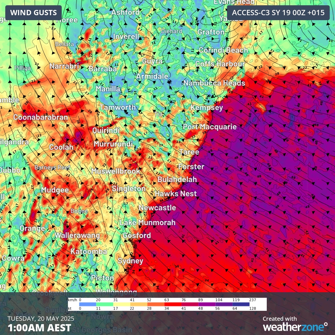
Image: forecast 10 metre wind gusts at 1am AEST on Tuesday, May 20.
Hazardous, large and powerful waves
The strong winds directed over coastal NSW have whipped up some wild ocean conditions on Sunday night. The Sydney waverider buoy recorded a maximum wave height of 10.1 metres at 8pm, with the significant wave height topping off at 5.1 metres. Significant wave height is the average of the largest 1/3 waves recorded over the measuring period–a value used to represent the noticeable ocean conditions for mariners. Significant wave heights exceeding 6 metres were also recorded at the Port Authority NSW buoys offshore of Port Botany and Port Newcastle.
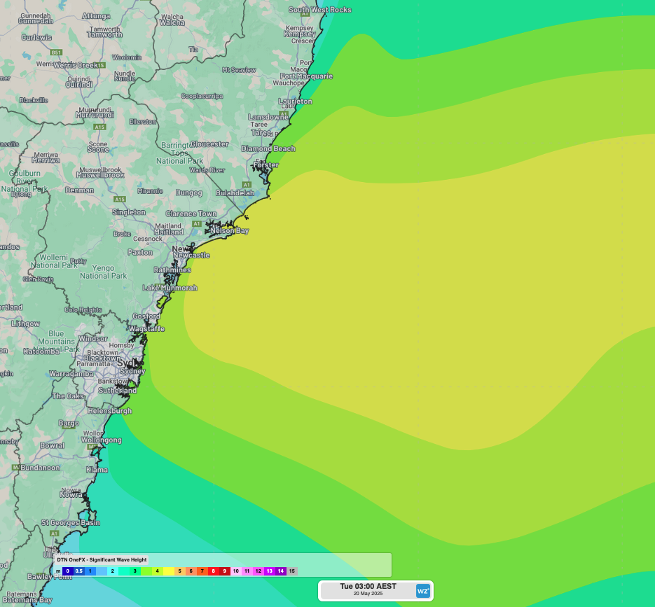
Image: OneFX significant wave height forecast for early morning on Tuesday, May 20.
As seen in the image above, large waves exceeding 4-5 metres will persist into early Tuesday, May 20. Parts of the southern Mid North Coast and Hunter coasts will be most impacted with strongest winds generating these large waves. However, coastal areas between the Illawarra and the Northern Rivers will also see large and unruly surf in the coming days before easing off from about Thursday.
Heavy and intense rainfall
The deep stream of moisture coming off the very warm Tasman Sea has brought heavy rainfall to parts of the coast between Forster and Ulladulla. As seen in the image below, 24-hour rainfall observations to 9am Monday, May 19, included widespread falls of 90-130mm over the Central Coast and Newcastle areas.
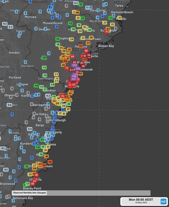
Image: Accumulated rainfall over eastern NSW in the 24 hours to 9am AEST on Monday, May 19.
Heavy rain will continue to soak eastern NSW over the coming days as persistent onshore winds continue to drive moisture-laden air over the state’s coast and ranges.
While there is some uncertainty about how far north and south the rain will spread this week, most forecast models agree that the Hunter and Mid North Coast regions will be a focus for heavy rain for several days. These areas could see 4 or 5-day rainfall accumulations reaching 300 to 400mm by Wednesday or Thursday.
Rain is also likely to reach further north and south this week, possibly spreading into parts of the Northern Rivers, Sydney Illawarra and South Coast districts, and onto parts of the adjacent ranges and tablelands. While falls in these areas are expected to be less intense than the Hunter and Mid North Coast, some places could still see heavy rain and flooding this week.
The maps below show the predicted accumulated rain this week from two different forecast models, highlighting the disagreement between various models.
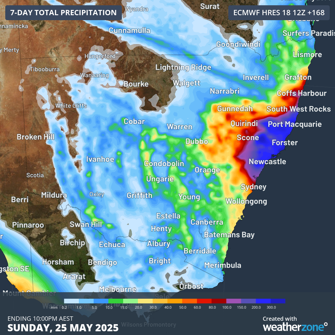
Image: Forecast accumulates rain this week, according to the ECMWF-HRES model.
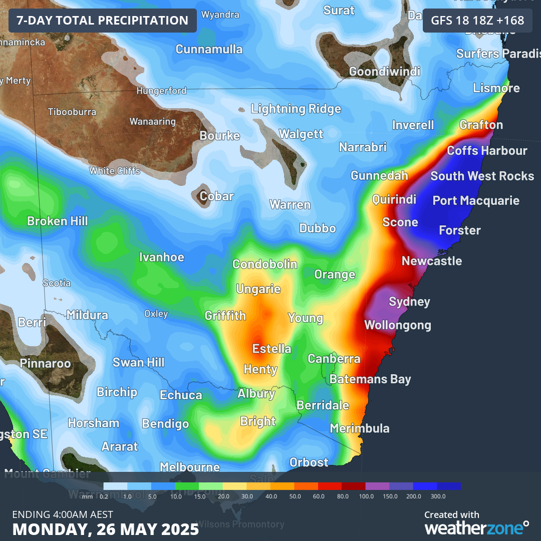
Image: Forecast accumulates rain this week, according to the GFS model.
This week’s rain is likely to cause areas of flash flooding and riverine flooding in eastern NSW. A flood watch has been issued for parts of the Northern Rivers, Hunter and Mid North Coast, with minor to moderate flooding likely and major flooding possible. Warnings are also in place for heavy rain, damaging winds and hazardous damaging surf. Check the latest warnings throughout the week for the most up to date information.
- Other news
- Mon 19 May 2025 Bitterly cold night in four states
- Sun 18 May 2025 How did one of Chicago's rarest extreme weather events occur?
- Sat 17 May 2025 NSW fog lingers longer inland
- Fri 16 May 2025 First significant mainland snowfall this weekend
- Fri 16 May 2025 Cold and wet weekend ahead for Melbourne