News
‹ back to weather news
News
-
Fina could be Australia's first November category 3 cyclone in 20 years
Anthony Sharwood, 21 November 2025Tropical Cyclone Fina is set to become the first category 3 cyclone in Australian waters in November since Cyclone Bertie-Alvin in 2005, and it could happen as early as Friday evening.
While there have been six tropical cyclones to form in Australian waters during the month of November since Bertie-Alvin over the past two decades, none of them reached category 3 – the threshold at which a tropical cyclone becomes a "severe" tropical cyclone, with gusts between 165 and 224 km/h.
What is Fina's current strength and position?
Fina weakened to a category 1 system on Thursday and became near-stationary around 100 km off the north coast of the Northern Territory overnight.
At 9:30am ACST on Friday, Fina was located about 325 kilometres northeast of Darwin, with sustained winds of 85km/h and wind gusts of 120 km/h near its core.
Weatherzone meteorologist Ben Domensino says that the atmosphere will become more favourable for the system to gain strength this Friday. This should allow Fina to regain a category 2 intensity once again.
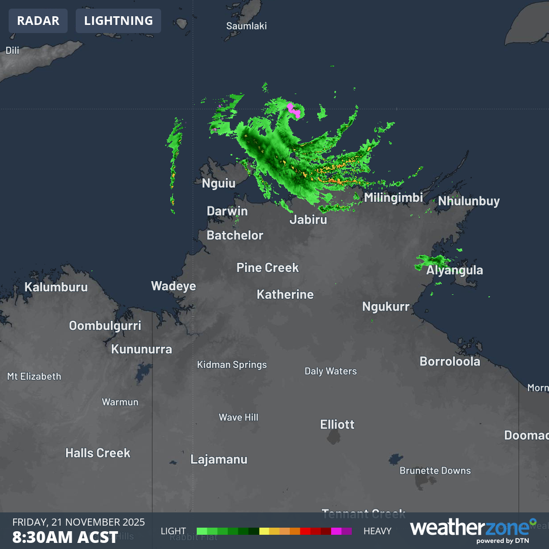
Image: Intense areas of rainfall on the radar associated with Cyclone Fina at 8:30am on Friday, November 21, 2025. Source: Weatherzone.
How destructive are Fina's winds and where is it heading next?
Fina is expected to pass over the Cobourg Peninsula and Tiwi Islands (northeast of Darwin) on Friday night into Saturday morning, most likely as a category 2 system with gales and damaging wind gusts possibly as powerful as 155 km/h.
The BoM warns that destructive wind gusts up to 155km/h may develop between Cape Don and Warruwi (on the eastern side of the Cobourg Peninsula) later today as Fina nears the coast. The Tiwi Islands could see similar gusts early on Saturday.
The BoM’s 6:30am (ACST) bulletin on Friday also stated that:
"There continues to remain a chance that it could reach category 3 intensity earlier, during late Friday or early Saturday as it moves into the Van Diemen Gulf."
The Van Diemen Gulf is an area of the Timor Sea, located between Darwin and the Tiwi Islands and Cobourg Peninsula to the city’s north and northeast respectively.
Sea surface temperatures are at least 30°C in the gulf at present, which is warmer than normal for this time of year. Those warm waters will provide energy for Cyclone Fina’s intensification.

Image: Sea surface temperatures in NT waters on November 19, 2025. Source: BoM.
Will Fina reach Darwin, and if so, what might the impacts be?
Tropical Cyclone Fina will pass near and possibly over Darwin on Saturday night into Sunday morning, and the BoM’s latest warnings say that destructive wind gusts up to 155km/h may develop over Darwin later on Saturday.
Heavy rainfall which may lead to flash flooding is also possible along coastal areas between the Tiwi Islands and Warruwi from Friday, extending to the coast and nearby inland across the western Top End including Darwin on Saturday.
In terms of actual rainfall totals, Friday’s forecast has changed little from yesterday, with widespread 100 to 300 mm likely over the northwest Top End, including the Darwin region, and isolated totals around 500 mm.
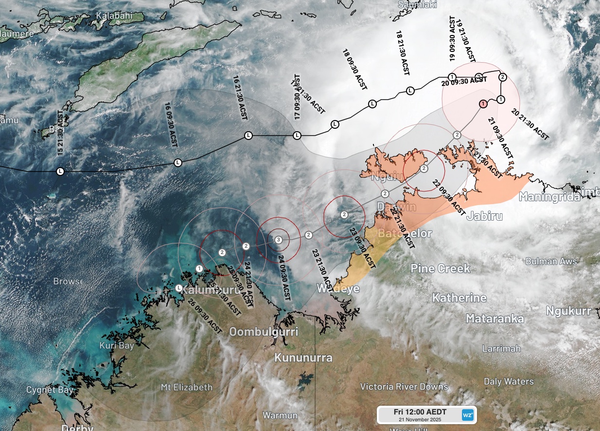
Image: The latest track map for Cyclone Fina, issued at 10:34am (ACST) on Friday, November 21, 2025. Source: Weatherzone.
What will Fina do after it passes through or near Darwin?
Once past Darwin, models suggest Fina will track over the southern Timor Sea and intensify on Sunday into Monday, possibly becoming a category 3 severe tropical cyclone (if it has not already reached that strength).
Increasing wind shear from Monday should then weaken the system as it approaches the north Kimberley coast early next week.
Check our Darwin forecast page and the BoM's tropical cyclone page for the latest information.
- Other news
- Fri 21 Nov 2025 How a tropical cyclone near Darwin will cause 47C heat over Australia next week
- Thu 20 Nov 2025 Tropical Cyclone Fina to pass near Darwin this weekend – here's what to expect
- Wed 19 Nov 2025 Tropical cyclone north of Australia, polar airmass to the south
- Wed 19 Nov 2025 Tropical Cyclone Fina forms north of Darwin, landfall possible this weekend
- Tue 18 Nov 2025 Tropical cyclone risk increasing near northern Australia