News
‹ back to weather news
News
-
Colossal low pressure system grips eastern Australia
Yoska Hernandez, 26 July 2025A colossal low pressure system—nearly half the size of the Australian mainland—is gripping central and eastern Australia. Spanning around 3.4 million km², its vast footprint is so extensive that tracing its boundary would take you on a 9,000 km journey. For perspective, that’s further than driving from Perth to Brisbane and back—twice.
This massive system is triggering warnings for damaging winds across NSW, Tas, and Vic, bringing showers and rain to the east and southeast, along with thunderstorms over southeast Qld.
Rainfall totals over the past 24 hours were as follows:
- SA: 15–70 mm;
- Vic: 15–60 mm;
- Tas and NSW: 15–35 mm;
- Qld: 15–50 mm.
A number of locations recorded their highest daily July rainfall in decades:
SA:
• Adelaide (West Terrace/Ngayirdapira): 29 mm – highest in 47 years;
• Edithburgh: 34 mm – highest in over 30 years;
• Mt Crawford AWS: 46 mm – highest in 30 years;
• Multiple other sites: highest July totals in 5 to 30 years.Vic:
• Longerenong: 29 mm – highest in 52 years;
• Ararat: 29 mm – highest in 35 years;
• Mildura: 19 mm – highest in 35 years;
• Stawell: 32 mm – highest in 29 years;
• Swan Hill: 24 mm – highest in 27 years;
• Horsham Aerodrome: 24 mm – highest in 27 years.As the trough pushed through the eastern inland, it sparked a remarkable 1,600 km-long line of thunderstorms stretching from Mt Isa through the outback of Qld into northern NSW. Warm and humid air from the northwest Indian Ocean and the Coral Sea to the northeast clashed with much colder southern air, fuelling the activity. Some outback locations in Qld also recorded notable falls. Thargomindah Airport received 22 mm, marking its highest daily July rainfall total in 5 years, while Charleville Aerodrome recorded 24 mm, the highest daily July rainfall in 3 years.
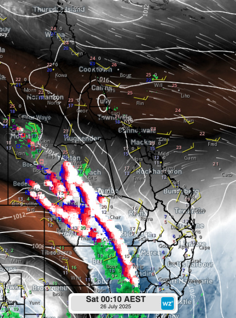
Image: Water vapour satellite image near midnight, Saturday 26th July. Thunderstorms were observed overnight across the Qld outback.
Very strong to damaging wind gusts have accompanied the system across several states:
Wind gusts observed across Vic, the NT and SA during Friday 25th July:
- Vic:
– Mt Hotham: 146 km/h;
– Mt Buller: 132 km/h;
– Kilmore Gap: 120 km/h;
– Melbourne Airport: 91 km/h;
– Mt William, Ben Nevis, and Thredbo: 107 km/h. - NT:
– Alice Springs Airport: 93 km/h. - SA:
– Neptune Islands: 93 km/h;
– Cleve Aerodrome: 91 km/h;
– Marree Aero: 89 km/h;
– Nullarbor: 85 km/h.
Wind gusts observed across Tas during today, Saturday 26th July:
- Tas:
– kunanyi / Mt Wellington: 87 km/h;
– Larapuna (Eddystone Point): 91 km/h;
– Flinders Island Airport: 91 km/h;
– Mt Read: 85 km/h.
As the low continues to drift east in the coming hours and days, very cold days are forecast across the east and southeast. Melbourne and Adelaide are expected to struggle to reach the mid-teens, while Canberra may barely surpass 10°C each day into early next week.
- Other news
- Wed 17 Sep 2025 Wettest September day in 37 years at Cairns Airport in unseasonable N Qld deluge
- Wed 17 Sep 2025 AFL Preliminary Finals weather: rain Friday, cold Saturday at the MCG
- Tue 16 Sep 2025 NSW shaken by three earthquakes in nine hours
- Tue 16 Sep 2025 Melbourne activates its 'rain shield', dodging moisture from the northwest
- Mon 15 Sep 2025 Negative Indian Ocean Dipole underway – here's what it means for Australia