News
‹ back to weather news
News
-
Historic flooding as eastern NSW deluge continues
Ben Domensino, 21 May 2025Flood records are being broken in parts of eastern NSW this week as relentless rainfall continues to dump water into already overflowing rivers and creeks.
A steady stream of moisture-laden onshore winds has been causing persistent rain over eastern NSW since Sunday. This three-day soaking has been enhanced by a slow-moving low pressure trough near the surface and a pool of cold upper-level air, resulting in localised heavy falls.
Video: Radar animation showing rain streaming over eastern NSW between Sunday and Tuesday.
Some areas of eastern NSW received more than 400 mm of rain in the 48 hours ending at 9am AEST on Wednesday, including:
- 449 mm at Mooral Creek
- 436 mm at Moppy Lookout
- 430 mm at Mount Seaview, including 319 mm in 24 hours and 118 mm in 6 hours
- 427 mm at Careys Peak
- 425 mm at Mount Barrington
- 412 mm at Comboyne Public School
- 416 mm at Taree Airport, equivalent to 4-5 months’ rain at this time of year
Major flooding hits record levels
The heavy rain from the past few days has resulted in major flooding across several river systems in the Hunter and Mid North Coast, including the Paterson, Gloucester, Manning and Hastings Rivers.
The river height of Manning River at Taree climbed above 6 m shortly after 1am AEST on Wednesday and had reached 6.39 m by 11am. This is a new record for this site, beating 5.97 m from 1929. A flood of this magnitude is exceptionally rare at Taree, having less than a 0.2% probability of occurring in any given year, meaning it is rarer than a 1-in-500 year flood event.
More rain to come
Despite already enduring several days of unrelenting wet weather, large areas of NSW will continue to see rain in the next few days.
Persistent rain with locally heavy falls will continue to soak the Mid North Coast and Northern Rivers and the adjacent tablelands on Wednesday and Thursday, before finally clearing from Friday.
Rain will also spread further south and west across other areas of NSW from Wednesday night into Thursday, before contracting towards southern NSW on Friday and clearing on Saturday.
The map below shows the forecast accumulated rain between Wednesday and Friday.
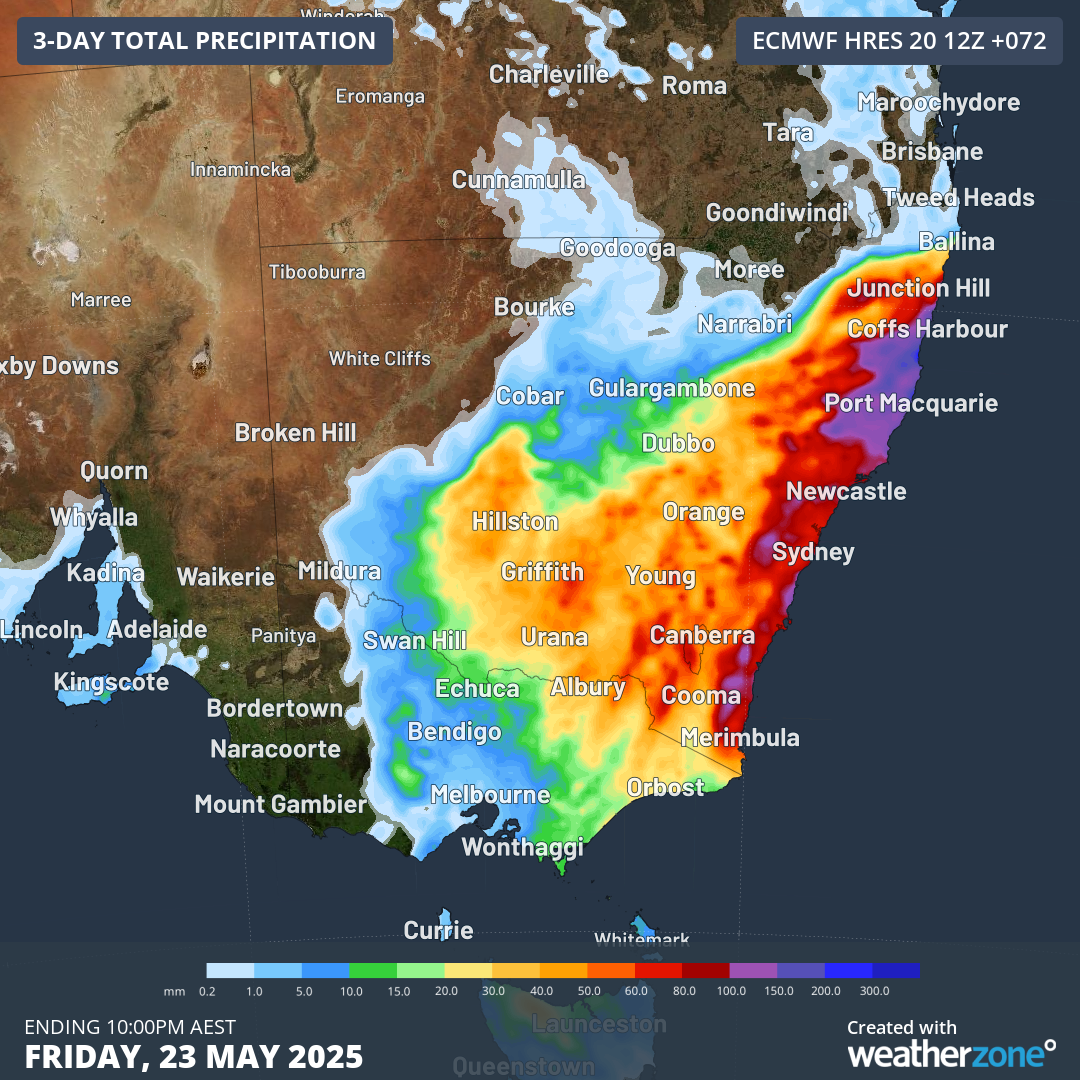
Image: Forecast accumulated rain during the 72 hours ending at 10pm AEST on Friday, May 23.
The magenta areas on the map above represent areas that could see more than 100mm over the next three days, although localised totals of around 200-300 mm are possible in the Mid North Coast.
The upcoming rain will be falling into already saturated river catchments, so flooding is a high risk. Be sure to check the latest flood warnings, weather warnings and road closures in your area over the next few days.
- Other news
- Wed 21 May 2025 Powerful polar blast roaring towards Australia
- Wed 21 May 2025 Indian monsoon onset on the doorstep
- Tue 20 May 2025 Big dry contributes to record cold SA, Vic mornings
- Tue 20 May 2025 Relentless rain to continue for flooded eastern NSW
- Mon 19 May 2025 Rain, waves and gales smashing eastern NSW