News
‹ back to weather news
News
-
Wild WA weather as Perth faces coldest day of winter 2025
Anthony Sharwood, 25 August 2025A strong cold front is roaring through Western Australia’s South West Land Division this Monday, bringing strong winds, heavy rain and frigid temperatures.
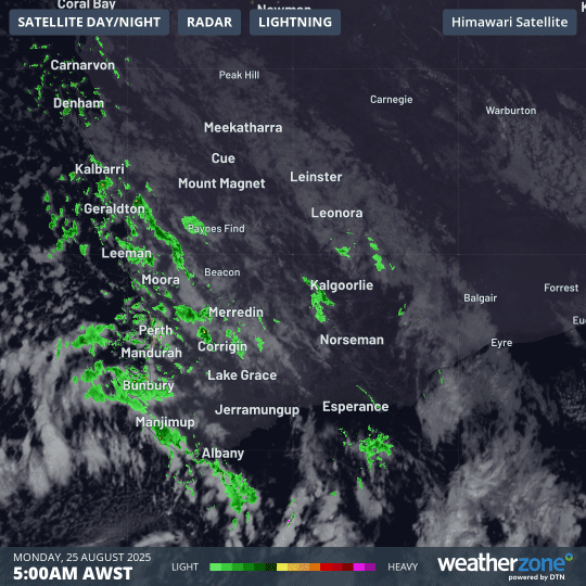
Image: Four-hour combined radar and satellite loop for southwest WA on the morning of Monday, August 25, 2025.
You can see the dynamic system in action above in the combined radar and satellite loop from 5am to 9am. It shows cloudbands with showers ahead of the front, then more showers embedded in the tell-tale speckled airmass which indicates a polar airmass surging northwards.
Rainfall
A total of 20.2mm of rain fell in Perth in the 24 hours to 9am Monday and the showers continue on Monday morning with the chance of storms.
The overnight rainfall brought Perth’s monthly running total to a healthy 169.8mm, with the long-term August average of 122.7mm now a blur in the rear vision mirror. Perth has exceeded its average rainfall in each of the three months of winter for the first time since 1996.
And Perth wasn’t alone in getting a good drenching. Virtually the entire southwest corner of WA received 24-hour rainfall totals between around 10mm and 25mm to 9am Monday, with some locations receiving up to 40mm or slightly more.
One place that did particularly well was Bonnie Rock, a tiny map speck (population 60) in the western reaches of the Central Wheat Belt forecast district, about four hours northeast of Perth. It received 38.5mm overnight, which exceeded its entire August monthly average of 36.8mm.
Showers will stick around for the next couple of days across the South West Land Division, although they will become far more likely in coastal areas.
Image: Perth radar on Monday morning on the Weatherzone app.
Cold temperatures
This airmass is particularly cold and is likely to deliver Perth its coldest maximum temperature of 2025 to date.
Perth’s coldest day so far this winter was July 28, when the mercury could only manage to reach 13.9°C.
While the official BoM forecast for Monday is a high of 14°C, Weatherzone’s forecast guidance indicates that the daytime temperature might only reach 12°C or 13°C.
According to at least one model, that would happen if winds swing southerly for a few hours during the day, preventing the influence of warming from the ocean that occurs in a classic southwesterly.
Maximums will be even lower across the South West and South Coastal forecast districts this Monday, with some locations likely to struggle to reach double digits.
It’s also worth keeping an eye on the apparent (or "feels like" temperatures):
- At 10am (AWST), Perth’s temperature was a very chilly 8.5°C while the apparent temperature was just 5.1°C.
- Further south, Albany's apparent temperature hovered below zero for a full hour between 6am and 7am.
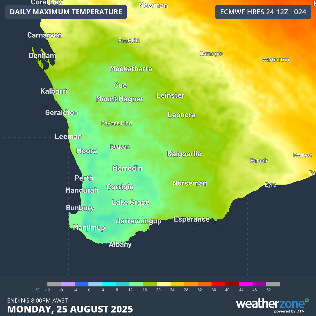
Image: Forecast maximums for southwest WA on Monday, August 25, 2025, according to the ECMWF model.
Strong winds
A gale warning is in place this Monday for the Leeuwin Coast, Albany Coast and Esperance Coast, while a strong wind warning has been issued for Perth Local Waters, the Ningaloo Coast, Gascoyne Coast, Geraldton Coast, Lancelin Coast, Perth Coast, Bunbury Geographe Coast and the Eucla Coast.
Since midnight, wind gusts of 80 km/h or higher have been recorded in at least three forecast districts in the South West Land Division.
Winds will stay strong for the next couple of days before the cold, showery conditions gradually ease by midweek – making this the last strong cold front of a productive 2025 winter for southwest WA in terms of much-needed rainfall in the region's wettest season.
- Other news
- Mon 25 Aug 2025 Rain, wind and snow to hit several Australian states this week
- Mon 25 Aug 2025 When will the Fiji surf pro finals day happen
- Sun 24 Aug 2025 On this day August 24, 1992, Hurricane Andrew impacts southern Florida
- Sat 23 Aug 2025 Short-lived typhoon to develop in the West Pacific
- Fri 22 Aug 2025 Sydney on verge of third wettest August on record