News
‹ back to weather news
News
-
Damaging winds in four states as record-challenging heat targets NSW
Ben Domensino, 22 October 2025This Wednesday will be a big day of extreme weather across southern and southeastern Australia, with damaging to destructive winds and thunderstorms hitting several states and territories as record-challenging heat causes Extreme fire danger in NSW.
An intense low pressure system and associated cold front will cross southeastern Australia on Wednesday. This potent system will interact with a sweltering air mass sitting over eastern Australia to cause a dynamic mix of extreme weather in multiple states and territories.
Wind and thunderstorms
Powerful winds will surge across parts of SA, Vic, NSW and the ACT on Wednesday as the low passes over Bass Strait and the cold front ploughs across Australia's southeast mainland. Severe weather warnings have been issued for damaging to destructive winds in all four of these states and territories on Wednesday.
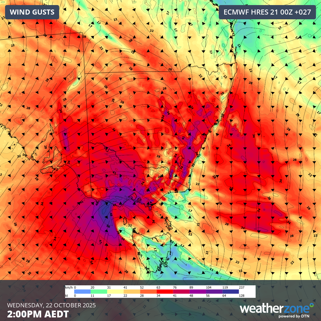
Image: Modelled wind gusts at 2pm AEDT on Wednesday.
Wind gusts on Wednesday could reach around 90 to 100 km/h over most of Vic, central and southeast SA to the east of the Mount Lofty Ranges, the southern and central coast and ranges in NSW and the southern ACT.
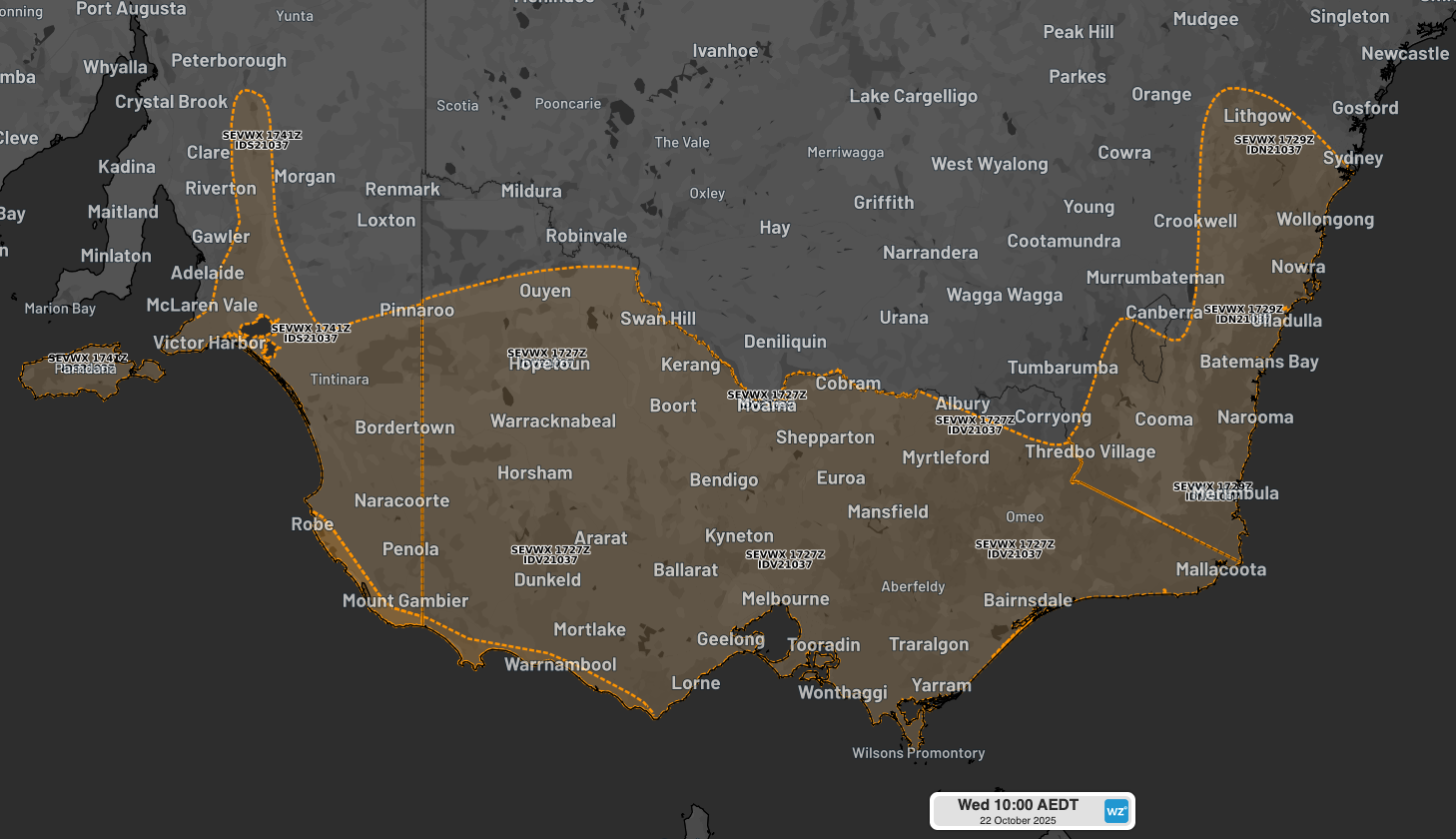
Image: Orange shading represents areas covered by a severe weather warning as of 10am AEDT on Wednesday, October 22, 2025.
The strongest winds are likely to occur near the low pressure system, with gusts possibly reaching around 110 to 130 km/h along the coast between Robe in SA and Cape Otway in Vic.
Thunderstorms will also develop over a broad area of southeastern Australia on Wednesday in response to the passage of the cold front and an associated low pressure trough. These storms will affect parts of SA, Vic, NSW and the ACT, and may also extend down to parts of Tas and up towards central Australia.
Heat and fire danger in NSW
A tongue of very hot air will be driven across NSW on Wednesday as northwesterly winds strengthen ahead of the approaching cold front and trough.
This hot air mass, which already broke October state maximum temperature records in NSW and Qld on Tuesday, could challenge October heat records in parts of eastern NSW on Wednesday.
Sydney’s forecast top of 39°C for Wednesday is higher than the city’s current October maximum temperature record of 38.2°C from 2004.
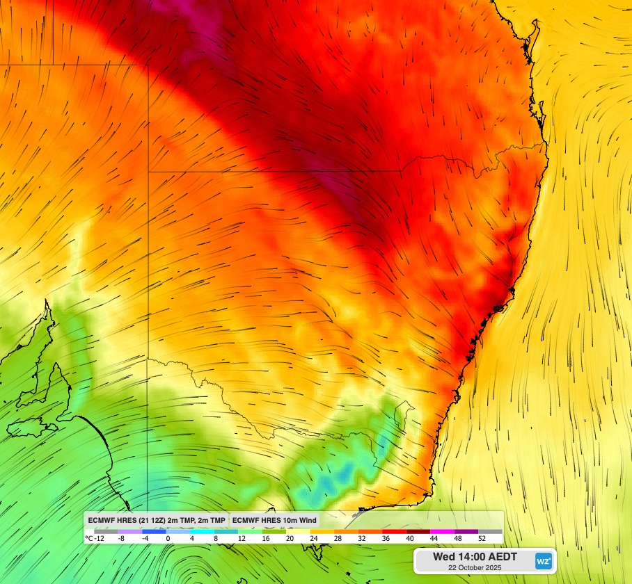
Image: Forecast temperature and wind at 2pm AEDT on Wednesday, October 22, 2025.
This burst of intense heat will combine with the blustery winds to cause High to Extreme fire danger ratings across most of NSW on Wednesday. Total fire bans have been issued over several districts in central and northern NSW, including the Greater Sydney, Greater Hunter and Illawarra/Shoalhaven forecast weather areas.
Be sure to check the latest severe weather warnings and severe thunderstorm warnings in your area on Wednesday if you live in southern or southeastern Australia. Those in NSW should also keep an eye on the NSW Rural Fire Service website for the latest information on fires across the state.
- Other news
- Wed 22 Oct 2025 October temperature records broken in searing Sydney heat
- Tue 21 Oct 2025 Hottest October day on record in Qld, NSW
- Tue 21 Oct 2025 Extreme fire weather to hit NSW on Wednesday
- Tue 21 Oct 2025 Rain, storms and strong winds sweep southern Australia
- Mon 20 Oct 2025 Outback October heat records broken in three states