News
‹ back to weather news
News
-
Burst of flooding monsoonal rain to surge north over India
Felix Levesque, 19 August 2025A surge of monsoonal winds and rain across northern India will top up an already plentiful monsoon season.
The Indian Southwest Monsoon to date
The graph below shows the distribution of monsoonal rainfall across the Indian sub-continent since the start of June.
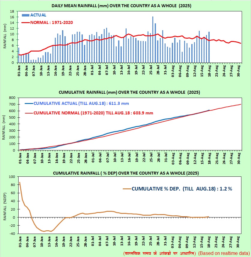
Image: Daily and cumulative monsoonal rainfall across India’s four homogeneous regions since June 1, 2025. Source: India Meteorological Department (IMD).
Parts of northern India experienced early monsoon rainfall in late May and early June before a dry spell extended into mid June. Rainfall has since come in steady bursts across the country, leading to a close to normal total monsoon rainfall cumulative, as seen below.
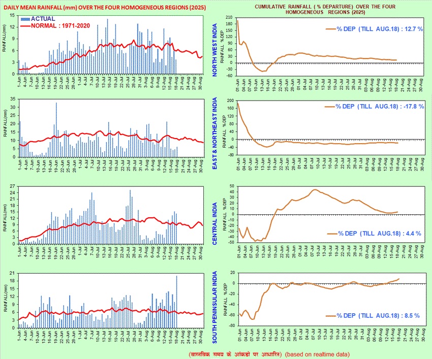
Image: Daily and cumulative monsoonal rainfall across India since June 1, 2025. Source: IMD.
Monsoon burst heading north
The animation below shows a deep surge of moist monsoonal southwesterlies moving north over India. Heavy rainfall over central parts of the country will spread into northern India later this week, lingering into early next week.
Video: 6-hourly precipitation and 950hPa (about 500m above sea level) winds over India between Tuesday, August 19, 2025, and Wednesday, August 27, 2025.
This burst of southwesterly winds and rainfall is associated with an active phase of the Madden-Julian Oscillation (MJO). The MJO is a region of enhanced cloud and rainfall that moves from west to east near the equator, moving around the globe over a period of roughly 30 to 60 days.
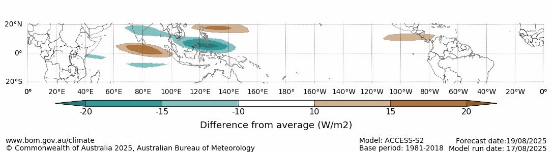
Image: Forecast outgoing long-wave radiation anomaly for August 19, 2025, associated with the Madden-Julian Oscillation. The green areas show where cloud cover is expected to be enhanced, while the brown shading represents suppressed cloud cover. Source: Bureau of Meteorology.
Across the coming week, broad parts of Western, Central, Eastern and Northern India will receive over 100 mm of rainfall, with 300-400 mm expected across parts of the Western Ghats, Bengal Basin, and Aravalli and Vindhya ranges.
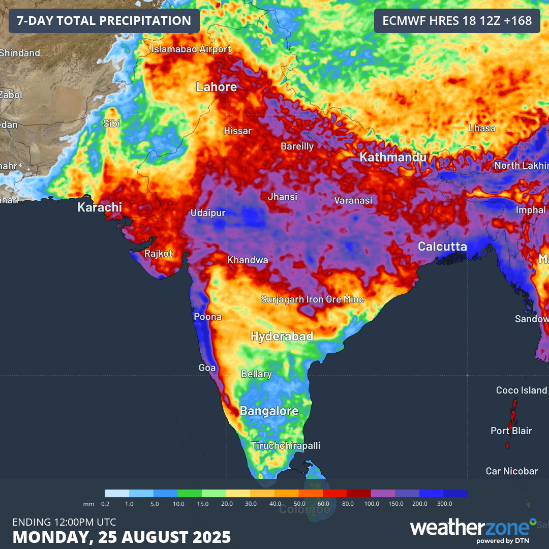
Image: Forecast rainfall accumulations over the next 7-days across the Indian sub-continent.
This burst of monsoonal rainfall will lead to flooding in some areas, with disruptions of transport and electrical networks possible.
- Other news
- Tue 19 Aug 2025 Cold front slams the southwest with wind, rain, storms
- Mon 18 Aug 2025 Yet another wet week for eastern Australia
- Mon 18 Aug 2025 Australia's coldest night of the year by more than three degrees
- Sun 17 Aug 2025 WA braces for more wet weather
- Sat 16 Aug 2025 Erin becomes the first hurricane of the 2025 North Atlantic Season