News
‹ back to weather news
News
-
Adelaide's coldest, wettest day of the year
Anthony Sharwood, 9 July 2025Adelaide and many nearby areas are having their coldest and wettest day of 2025 to date, with bleak wintry weather that will be considered a blessing by many locals after a desperately dry start to the year.
The culprit for the wintry weather is a cold front which surged across the Great Australian Bight overnight, crossing the South Australian coastline on Wednesday morning.
Wednesday’s significant rainfall readings between 9am and 3pm (ACST) included:
- 19.6mm in Adelaide, which beat this year's previous wettest day of 15mm on May 27.
- 34.6mm at Mount Lofty, where the 3pm temperature was 4.3°C with an apparent or "feels like" temperature of –1.2°C. Snow flurries are possible on Wednesday evening.
- 35.4mm at Parawa West, about 70km south of Adelaide.
Rainfall was intense at times, with three-hour totals exceeding 20mm at numerous locations in the Adelaide Hills from Wednesday morning through to lunchtime.
Wednesday’s significant temperatures between 9am and 3pm (ACST) included:
- A high of 5.8°C at Mount Lofty just after midday.
- A high of just 10.1°C in Adelaide, also just after midday.
- A high of 11.8°C just after 1pm at Port Lincoln on the Eyre Peninsula.
It’s important to understand that the temperatures mentioned above are not yet the official maximums – as maximum temperatures are the highest reading of a 24-hour period between 9am and 9am.
Indeed, the mercury rose marginally to 10.7°C in Adelaide at 4:46pm. However it appeared to be on a downwards trajectory again as darkness encroaches, and this Wednesday will almost certainly be the coldest day of 2025 to date, eclipsing the 13.3°C which occurred twice in June.
Wednesday will also likely be the coldest of 2025 to date by at least two degrees in Port Lincoln and numerous other South Australian locations.
Numerous South Australian locations are also likely to register their coldest days (in any month) in four years or longer. This includes Adelaide.
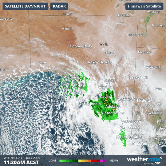
Image: Four-hour combined satellite and radar loop showing the tell-tale speckled cloud pattern associated with cold, unstable polar airmasses surging towards South Australia.
While this strong cold front will continue to push eastwards overnight – bringing strong winds, rain and a wintry chill to much of southeastern Australia on Thursday with snow at higher elevations – it is not yet finished in South Australia.
Indeed, snowfalls are possible this evening as far north as the Flinders Ranges, which rise to 1171m at St Mary Peak (Ngarri Mudlanha).
The Flinders Ranges are in a relatively arid part of the state, but as the radar loop above shows, moisture is being pushed in that direction (the ranges lie about 300km NE of the town of Whyalla, which is shown on the map).
Any snowfalls will likely occur after dark, but we’ll share any reports and images we can find on Thursday morning if snow does settle.
Speaking of snow, the alpine resorts of NSW and Victoria are in for a big 24 hours of blizzards, with a dump of 20 to 40cm on the cards. Check our snow page for the latest live cams, forecasts and more.
- Other news
- Sat 30 Aug 2025 Gusty polar blast turns southeast Australia snow white
- Fri 29 Aug 2025 Antarctic air to bring low-level snow in southeastern Australia
- Fri 29 Aug 2025 Rare tornado warning in Adelaide as storms, powerful winds slam SA
- Thu 28 Aug 2025 Northern WA and Southeast Australia face elevated fire risk this spring
- Thu 28 Aug 2025 Days of damaging winds ahead for southeastern Australia