News
‹ back to weather news
News
-
NSW shaken by three earthquakes in nine hours
Ben Domensino, 16 September 2025Three separate earthquakes were detected across NSW on Monday night into Tuesday morning, with reports of shaking coming in from the coast to the state’s far west.
According to Geoscience Australia, the trio of earthquakes occurred between 11pm on Monday and 8am on Tuesday AEST.
Earthquake 1
The first tremor of this sequence was a 3.8 magnitude earthquake that occurred shortly after 11pm to the west of the Macquarie Marshes, roughly 50 km to the southwest of Carinda. Despite occurring in a sparsely populated part of the state, shaking from the earthquake was felt in at least three separate locations to the west of the epicentre.
Earthquake 2
Monday night’s earthquake was followed by a shallow 3.7 magnitude earthquake near Muswellbrook in the Hunter Valley just after 2:20am on Tuesday. The epicentre of this earthquake was at the site of the Mount Arthur Coal Mine, a region that has seen a flurry of earthquakes in recent years, including magnitude 4.7 and 4.4 earthquakes on two consecutive days in August 2024.
While mining operations can induce weak and shallow earthquakes, less than magnitude 2, research has shown that even large open pit mines are not able to trigger moderate or strong earthquakes.
Earthquake 3
A third earthquake occurred near Bulahdelah just before 7:50am on Tuesday. This 3.1 magnitude tremor occurred at a depth of 9 km and was felt from Nelson Bay up to Forster and inland to Maitland, with Geoscience collecting around 100 felt reports across the Hunter and lower Mid North Coast regions.
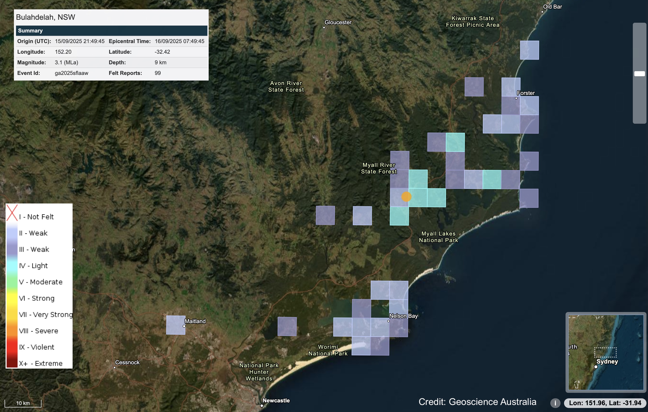
Image: Felt grid for the Bulahdelah earthquake on Tuesday morning. Source: Geoscience Australia.
How common are earthquakes in Australia?
Australia is in a relatively stable region of the planet for earthquake activity. Earthquakes are more common and stronger along Earth’s tectonic plate boundaries, which are the areas where large pieces of Earth’s crust meet each other.
Australia is classified as a ‘stable continental region’, which means it sits far away from any major plate boundaries. While this does not make Australia immune to tremors, it means that most earthquakes in Australia are shallow, but they can still be powerful.
On average, Australia experiences about 100 earthquakes of magnitude 3 or more each year, while earthquakes exceeding magnitude 5 only happen about once every two years. Stronger earthquakes exceeding magnitude 6 only happen about once per decade in Australia.
One aspect of earthquakes that is often misunderstood is how much more powerful they become as you move up through the moment magnitude scale. Every whole unit you go up represents a 30-fold increase in the amount of energy released by the earthquake. This means that a magnitude 6 earthquake releases 27,000 times more energy than a magnitude 3 earthquake (30 x 30 x 30).
You can track the latest earthquake activity in Australia on the Geoscience Australia website.
- Other news
- Tue 16 Sep 2025 Melbourne activates its 'rain shield', dodging moisture from the northwest
- Mon 15 Sep 2025 Negative Indian Ocean Dipole underway – here's what it means for Australia
- Mon 15 Sep 2025 Severe weather warnings in five states in warm, windy start to the week
- Sun 14 Sep 2025 Wet and windy weekend for the west
- Sat 13 Sep 2025 Spring warmth to spread across Australia's southeast