News
‹ back to weather news
News
-
Massive real-time temperature contrasts across Australia
Anthony Sharwood, 27 August 2025Australia is always a land of weather contrasts, and especially as late winter merges into early spring, but this week we should see real-time temperature differences of well over 40°C at opposite ends of the country.
Down south, a series of strong cold fronts are injecting a bitterly cold Antarctic airmass across southeastern Australia from this Wednesday right through until Sunday.
Maximums of -4°C are expected from Thursday through to Saturday for our highest alpine weather stations like Thredbo Top Station.
Up north, late dry season heat is really ramping up, with the first 40-degree day in sight for parts of northern WA and the NT, including the tiny community of Daly River, about two hours’ drive south of Darwin.
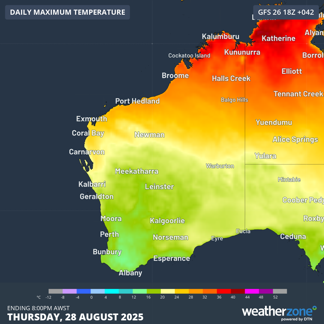
Image: Forecast maximums for WA and adjacent parts of SA and the NT for Thursday, August 28, 2025, according to the GFS model.
The map above shows predicted maximums (according to the GFS model) for the western half of the country. The areas of dark red in far northeastern WA and northwestern parts of the NT show temperatures of 40°C or slightly higher.
Maximums around 40°C would be at least five degrees above average for August at most locations in this part of Australia, where the hottest months are in mid-to-late spring before the wet season sets in.
But heat has been slowly building in this region, with Victoria River Downs cattle station already reaching 39.1°C on Tuesday, its hottest August day in 55 years. According to Weatherzone meteorologist Joel Pippard, the buildup of heat is due to last week’s stagnant weather pattern.
"The most recent pattern of frequent cold fronts down south has helped to concentrate the heat into a line, create a sharp temperature contrast across the country," Pippard added.
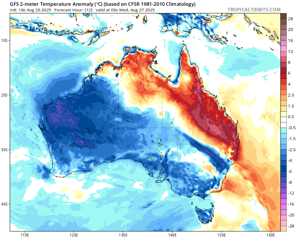
Image: Forecast temperature anomalies for Australia for 4pm, Wednesday August 27, 2025. Source: Tropical Tidbits.
As for the situation in southern Australia, the loop below shows the dynamic low pressure system situated west of Tasmania shovelling a polar airmass towards Tasmania and the southeast mainland.
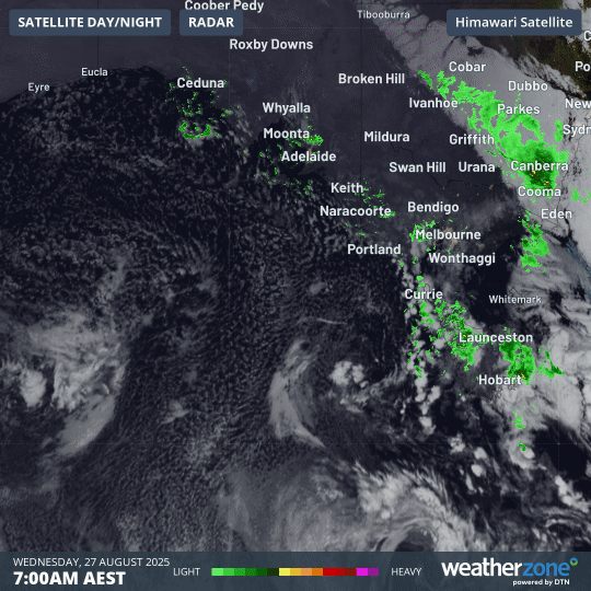
Image: Four-hour combined satellite loop as dawn breaks over SE Australia on Wednesday, August 27, 2025.
The cold air arrived on the mainland around breakfast time on Thursday after torrential rain in the alpine region that brought 90mm to Perisher Valley in NSW.
The mercury is now in the negative at Perisher and elsewhere in the high country and will remain that way for several days with heavy snowfalls imminent.
- Other news
- Tue 26 Aug 2025 Biggest, coldest blizzard of the season about to hit the alps
- Tue 26 Aug 2025 Rain arriving where it is desperately needed in Victoria, Tasmania and South Australia
- Mon 25 Aug 2025 Rain, wind and snow to hit several Australian states this week
- Mon 25 Aug 2025 Wild WA weather as Perth faces coldest day of winter 2025
- Mon 25 Aug 2025 When will the Fiji surf pro finals day happen