News
‹ back to weather news
News
-
Northern Hemisphere’s tropical cyclone season has started
Maryam Al-Ansari, 26 May 2024The Atlantic hurricane season officially starts on June 1st of each year. However, in 2024 the US National Hurricane Centre started issuing warnings for tropical storms from May 15th, and for good reason too.
Though no hurricanes have been observed in the Atlantic or Eastern Pacific as of yet, the Joint Typhoon Warning Center has warnings for two different systems present in the waters around Asia.
Just last Tuesday, a tropical disturbance east of Sri Lanka formed and has now intensified into Tropical Cyclone Remal over the Bay of Bengal.
.gif)
Fig. 1) Infrared satellite image of Tropical Cyclone Remal over the Bay of Bengal over the 3-hrs between 20:20 UTC to 23:20 UTC on May 25th.
Remal is expected to make landfall along the India/Bangladesh border early tomorrow morning local time. The storm looks to swing eastward, heading further inland into Bangladesh as it weakens. The remnants of the storm then look to persist until midweek. The system could bring sustained winds exceeding 90km/h, with gusts possibly exceeding 120km/h, to the coasts of Bangladesh and West Bengal. Rainfall exceeding 300mm is possible to central and eastern Bangladesh, the eastern India districts and western Myanmar over the next 3 days, with some regions possibly exceeding 1000mm.
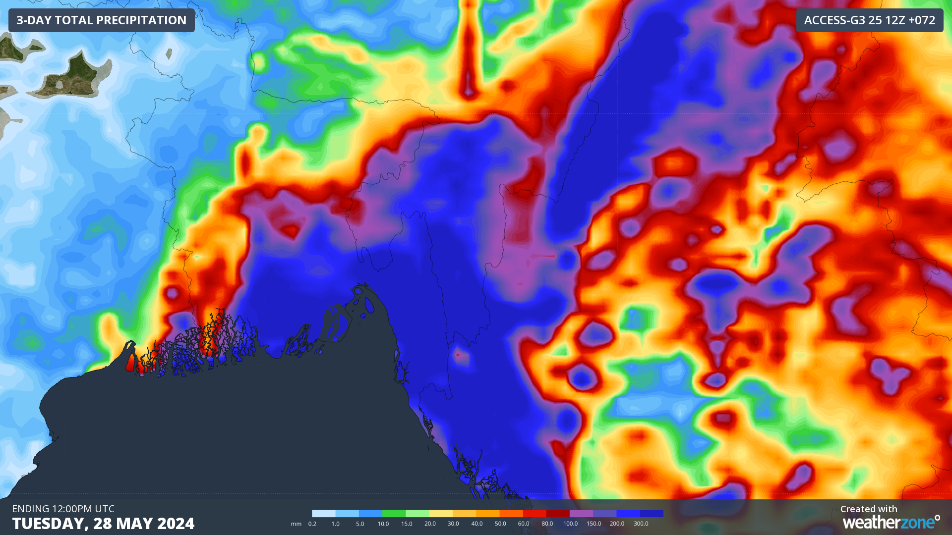
Fig. 2) Forecast accumulated rainfall over the next 72 hours using ACCESS-G 25/05 12Z over the Bay of Bengal’s east coast.
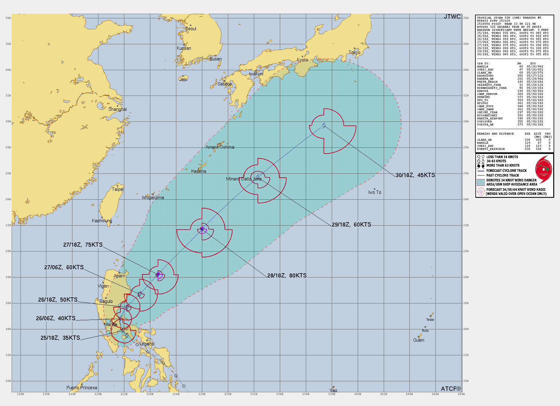
Further east, the waters north of Australia in the western Pacific are primed and ready for intense storm development as well. Tropical Storm 01W, which is currently lingering over the Philippines’ Luzon Island, is expected to travel northeast over the Philippine Sea in the next 4 days. As it does, it may develop into a typhoon due to favourable storm conditions over tropical waters. Development into a typhoon looks to occur as early as Tuesday the 28th of May, with winds reaching the winds of a category 3 Tropical Cyclone (wind gusts up to 224km/h). Thus far, the typhoon looks to continue to travel over western Pacific waters until it exits the tropics, weakening to a storm to the south of Japan. Below is the warning graphic for Tropical Storm 01W issued at 25/2100Z by the Joint Typhoon Warning Centre showing the forecast path of this potential typhoon.
Keep an eye out for future updates with regard to Tropical Cyclone Remal and the development of Tropical Storm 01W via the Joint Typhoon Warning Centre site: https://www.metoc.navy.mil/jtwc/jtwc.html.
- Other news
- Mon 17 Jun 2024 Mountainous surf
- Mon 17 Jun 2024 Six Aussie states below zero degrees this morning, more to come
- Sun 16 Jun 2024 Extreme heat in Mecca as 2 million people perform Hajj today
- Sat 15 Jun 2024 Where is the rain in Queensland?
- Sat 15 Jun 2024 Sydney’s six day dry spell broken to start the weekend