News
‹ back to weather news
News
-
Rain outlook for southwestern Australia
Ashleigh Madden, 22 April 2024March was a wet month for large areas of WA with several sites recording the highest daily rainfall on record, however the state’s southwest remains abnormally dry.
Much of this rainfall fell between the 9th and 13th of March across central and southeastern parts of the state after a slow-moving trough and tropical moisture brought heavy rain and thunderstorms.
Unfortunately, this rainfall event missed the parched southwest, with the region recording hardly any rainfall in March.
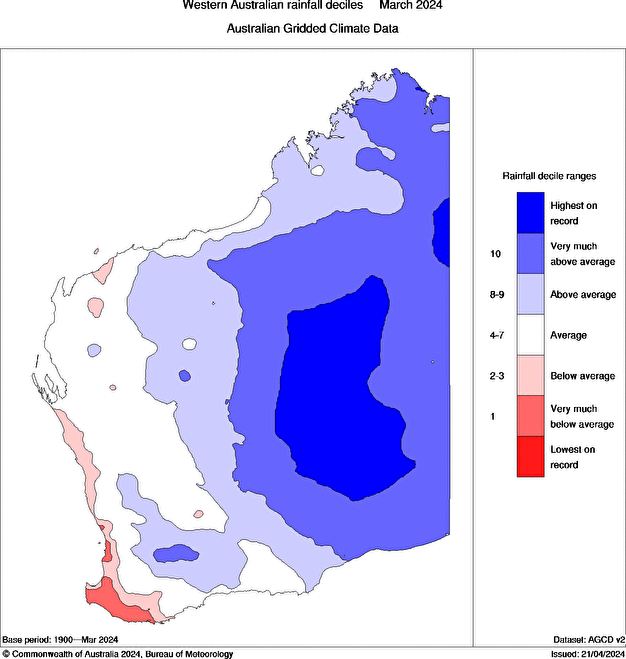
Image: WA rainfall deciles in March 2024, Source: Bureau of Meteorology
The rainfall through inland parts of WA last month has replenished soil moisture in the region with some areas recording the highest root-zone soil moisture on record in March 2024. The maps below show that soil moisture in March 2024 has improved dramatically since October 2023, when much of Australia was experiencing the driest three-month period on record between August to October 2023.


Images: Root-zone soil moisture deciles for October 2023 (bottom) and March 2024(top), source: Bureau of Meteorology.
While the interior of WA saw healthy rain in March, below average soil moisture continues to impact the state’s southwest.
Fortunately, we are moving into the wetter months of the year for southwestern WA, with the highest monthly rainfall typically falling between May and October.
The chart below shows Perth’s average monthly rainfall, with the most rain occurring during July.

Late autumn and winter are an active time of year for thunderstorms in southwestern Australia. Most of these thunderstorms and rain events are linked to cold fronts sweeping across the country during the winter months.
Models suggest that WA could see fewer rain-baring cold fronts in the next few months on average, due to a positive phase of the Southern Annular Mode.
However, when fronts do come through, they have the potential to produce decent rainfall and thunderstorms. This is because there are unusually warm waters sitting off the WA coastline, which could provide additional moisture to these cold fronts. The map below shows the warm sea surface temperatures (SSTs) off the coast.

The maps below show the monthly rainfall anomaly outlooks for May and June across Australia.


Average to below average rainfall is expected across WA during the next few months, but the models hint at locally above average rain in the southwest in June. This is likely due to above average sea surface temperatures near the southwest coast.
In summary, models are suggesting near to slightly below average rainfall for much of WA in May, with the potential for locally above average rain as we move into winter. We are now transitioning to the wettest time of the year for southwest WA, so even areas that see below average rain in the coming months are unlikely to be completely dry.
- Other news
- Fri 03 May 2024 Heaviest May rainfall in 82 years recorded in WA town
- Fri 03 May 2024 Rain and storms spreading across NSW
- Thu 02 May 2024 Will another positive Indian Ocean Dipole brew in 2024?
- Thu 02 May 2024 Rare rainless Agfest thanks to blocking high
- Thu 02 May 2024 400km line of severe thunderstorms lashing southwest WA