News
‹ back to weather news
News
-
Rain and severe storms lash southern WA
Anthony Sharwood, 5 November 2025Unseasonable rain is falling across large parts of Western Australia this Wednesday and is set to continue into Thursday as an active cut-off low pressure system and associated troughs cross the southern half of the state.
While Perth caught only 7.2mm millimetres of rain overnight, numerous locations in the state’s South West Land Division received falls in the 10-20mm range in the 24 hours to 9am Wednesday.
November is usually when the southwest starts to dry out dramatically, but rain and scattered storms continue this Wednesday from the Gascoyne to the Goldfields and plenty of places in between.
Just after 2pm (AWST), the BoM issued a severe thunderstorm warning for large hailstones, damaging winds and heavy rainfall for people in parts of the Central West, Great Southern, Central Wheat Belt, Gascoyne, Goldfields, Lower West and South West forecast districts.
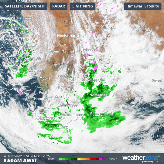
Image: Combined satellite and radar loop for southwest WA in the four hours from 8:50am to 12:50pm (AWST) on November 5, 2025.
The chart above shows the dynamic action of the low centred over the sea just off Geraldton this Wednesday.
Bands of cloud with associated areas of rain (green on the Weatherzone radar) can be clearly seen pushing across a large area, with the rain arriving from an unusual northeasterly direction in places like Albany in the state’s South Coastal forecast district.
28.8 mm was recorded during a thunderstorm at Arradale, a weather station just southeast of Geraldton, in only half an hour just before 2pm.
The wet weather will reach the Southern Interior and Eucla forecast districts by Thursday, and as this system tracks east, it’s worth noting that parts of WA’s southern and eastern interior have already seen unusually wet weather in recent times. For example:
- Kalgoorlie saw its heaviest day of October rainfall on record last month, with 60mm, and has picked up another 8.4mm from this event to 1pm (AWST) with more expected.
- Eucla, way out on the Nullarbor just 11km from the SA border, picked up 46mm on the first day of this month, on the back of almost 100mm in October. Its average rainfall in both months is only around 20mm.
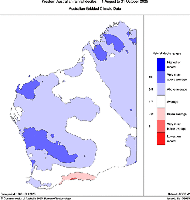
Image: The unusual sight of almost all of WA seeing average or above-average rainfall over a 3-month period from the start of August through to the end of October. Source: BoM.
As the chart above shows, almost all of WA has had a comparatively wet time in the past three months – with the exception of the region around Esperance which is seeing handy falls this Wednesday.
Even after a wet winter and early spring, most West Australians who live in the state’s southwest corner will welcome the current rain event after years of annual rainfall deficiencies, as they head into what are traditionally the driest months.
- Other news
- Wed 05 Nov 2025 Vietnam deluge close to world record for highest daily rainfall
- Tue 04 Nov 2025 Tropical cyclone season begins with warm oceans surrounding northern Australia
- Tue 04 Nov 2025 Snowing in Victoria on Melbourne Cup Day
- Mon 03 Nov 2025 Hottest October on record in Queensland, Northern Territory
- Mon 03 Nov 2025 7.7 million lightning pulses over Australia in one week