News
‹ back to weather news
News
-
NSW fog lingers longer inland
Brett Dutschke, 17 May 2025This morning, fog became widespread across New South Wales, plunging large areas into low visibility, including Sydney. Fog has lifted and burnt off in most areas, but is lingering well into the day in some inland places.
This morning, fog led to low visibility across large areas of New South Wales, including Sydney, and is still lingering in some inland areas.
By about 9am, fog had lifted and burnt off in most areas (mainly near the coast), and an hour or so later was still lingering in some inland places due to the calmness of the wind. At Bathurst Airport, fog lingered until about 10:30am.
In Sydney, fog was thickest in the west, as usual, but travelled from there along the Parramatta River in a conveyor belt of light winds, smothering the CBD's tall buildings.
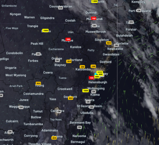
Image: Low cloud and fog and observations of visibility in metres at 7am, indicating many locations with visibility below 1000 metres.
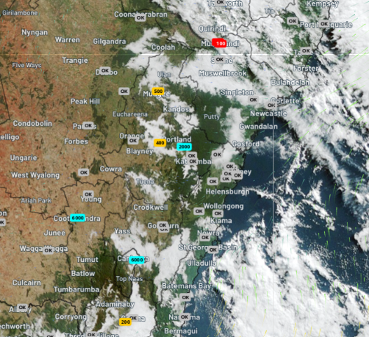
Image: Low cloud and fog and observations of visibility in metres at 9am, indicating fog persisting along the ranges and slopes while the coast becomes mostly clear.
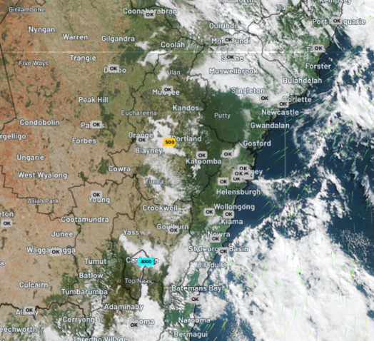
Image: Low cloud and fog and observations of visibility in metres at 10:30am, indicating Bathurst area under low cloud and in low visibility.
At the fog's thickest, visibility was reduced to less than 50 metres in Camden and Goulburn, and less than 100 metres in Richmond, Cooma, Bathurst, Mudgee, Maitland, Port Macquarie, Tamworth and Armidale, a hazard for those on the road. At Bathurst Airport, visibility was still as low as 500 metres until 10:30am.
This fog was a result of recent rain due to a trough, then calming winds and clearing skies due to a high. The rain had ensured high humidity on and near the ground, then calming winds and clearing skies allowed it to cool enough overnight for the high humidity to be converted into low cloud and fog.
Looking ahead to tonight and tomorrow morning across NSW, fog is unlikely to be as widespread or as long-lasting due to strengthening winds reducing overnight cooling. These strengthening winds will be a result of a developing low pressure system, which will bring significant rain to the state's east during the next few days, but that's another story.
- Other news
- Fri 16 May 2025 First significant mainland snowfall this weekend
- Fri 16 May 2025 Cold and wet weekend ahead for Melbourne
- Thu 15 May 2025 Eastern NSW bracing for heavy rain
- Wed 14 May 2025 Australia's snow season forecast 2025: slow start then promising second half
- Wed 14 May 2025 South Australia’s desperately dry peninsulas