News
‹ back to weather news
News
-
Coldest Sydney day in over a year as eastern NSW rain sets in
Anthony Sharwood, 31 July 2025With a maximum of just 12.4°C on Wednesday, Sydney shivered through its coldest day in more than a year.
Unusually, the maximum occurred just before midnight. Wednesday's highest temperature during daylight hours was 11.6°C, however the mercury rose briefly late at night as the steady rain eased off for an hour or so.
- The most recent day with a maximum below 13°C in Sydney was June 22, 2024, when the high was just 12.1°C.
- July is typically Sydney’s coldest month for both maximums and minimums. Yesterday’s maximum was exactly four degrees below the July average maximum of 16.4°C.
- Sydney’s coldest day on record in July (or any month) was a frigid Sunday way back on July 19, 1868, when the mercury peaked at just 7.7°C.
- Sydney also picked up 54.8mm of rain in the 24 hours to 9am Thursday – the third-heaviest rainfall day of 2025 to date.
Why was it so cold?
The two key ingredients for a chilly day were a pool of upper-level cold air over NSW and a low pressure system which funnelled moisture onshore, causing steady rain throughout the day.
While Sydney had reached 11.2°C by 9am on Wednesday, the mercury never got a chance to push much higher due to a consistent lid of cloud over the city.
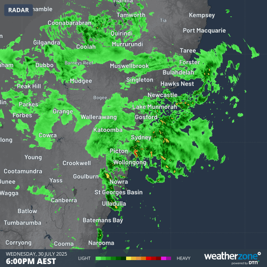
Image: 12-hour radar loop from 6pm Wednesday to 6am Thursday showing persistent bursts of rainfall lashing Sydney and nearby parts of NSW.
What's next for Sydney and eastern NSW?
While Thursday morning has dried out rapidly across the city after a period of intense morning rainfall in some suburbs, heavy rain will likely return this week as a complex low pressure system intensifies off the northern NSW coast.
The heaviest rain in NSW should occur from the Mid North Coast all the way down to the northern part of the South Coast forecast district. Sydney is located more or less in the middle of that stretch of coastline, so it can also expect more heavy rainfall on both Friday and Saturday.
Strong winds and powerful swells persisting well into the weekend are another factor to watch with this system, with strong wind warnings already in place for the entire NSW coastline.
READ MORE: Intense complex low to pummel eastern Australia this weekend
Away from the coast, enough moisture could cross the ranges to produce snow showers on the NSW Central and Northern Tablelands above about 1200m as the cold air pool lingers.
Snow was already recorded on the Central Tablelands on Wednesday, with the road to the 1397m summit of Mt Canobolas near Orange closed due to icy conditions.
There's even the possibility that a few flakes could push into the Granite Belt in southern Queensland on Saturday.
- Other news
- Wed 30 Jul 2025 Rare prospect of snowfalls in seven Australian states this week
- Wed 30 Jul 2025 Intense complex low to pummel eastern Australia this weekend
- Tue 29 Jul 2025 The Indian Ocean Dipole plunges into negative IOD territory
- Tue 29 Jul 2025 Deepest July snowpack in a decade at Victoria's highest ski resort
- Mon 28 Jul 2025 Cold week ahead for Australia with rain looming for east coast