News
‹ back to weather news
News
-
Rare twin sets of 'morning glory' clouds over Gulf of Carpentaria
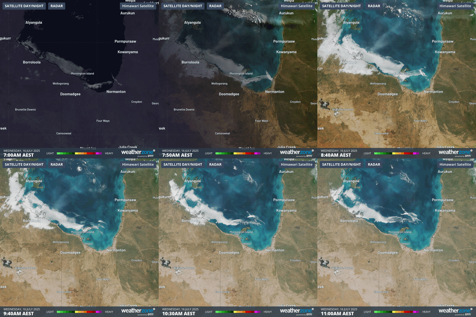
Anthony Sharwood, 16 July 2025Satellite imagery has captured a rare case of twin sets of "morning glory" clouds rolling across the Gulf of Carpentaria in different directions on Wednesday morning.
Morning glory clouds are the local name for either a long solitary roll cloud or a sequence of roll clouds.
These spectacular tubular clouds appear periodically over far northern Queensland and the Gulf of Carpentaria, typically in the latter half of the northern dry season. They usually occur in the morning, hence their nickname.
Typically, morning glory clouds move from east to west, and indeed we saw some of those this morning.
But the four-hour satellite loop below also shows a set of morning glory clouds rolling northwards, starting off near Burketown (which lies about 200km west of Normanton, whose location can be seen on the map).

Image: Four-hour satellite loop over the Southern Gulf of Carpentaria on the morning of July 16, 2025, showing two sets of morning glory clouds.
By about 9am, the two sets of clouds had merged into one cloudmass flowing in a general northwesterly direction.
What causes morning glory clouds?
The classic east-to-west morning glory clouds typically develop when:
- Opposing onshore winds or sea breezes converge over Cape Yorke Peninsula at night, causing air to rise. This air then descends at night.
- If a low-level temperature inversion is in place over the Gulf of Carpentaria, this descending air can trigger an atmospheric gravity wave that usually travels towards the west over the Gulf of Carpentaria.
- One or more roll clouds can form at the crests of these atmospheric gravity waves, because cooler air causes condensation near the wave crest, while sinking air behind each roll cloud causes clear air.
As for the south-to-north morning glory clouds that intersected with the classic east-to-west ones this morning, they were propelled by a cold front that had pushed unusually far north into western Queensland.
One other factor worth noting in the loop above is that it shows winter fog dissipating from coastal parts of the Northern Territory’s Carpentaria forecast district.
Fog is quite common in that region at this time of year, but uncommon in Darwin, which is much less exposed to easterly winds and needs a rare combination of atmospheric conditions for fog to form.
- Other news
- Tue 15 Jul 2025 Snowy week in Tasmania with three cold fronts on the horizon
- Tue 15 Jul 2025 Daytime chill across NSW with cloudband
- Mon 14 Jul 2025 Cold fronts and cloudbands to bring rain and snow in Australia this week
- Mon 14 Jul 2025 Tropical Storm Nari threatens Tokyo and northern Japan
- Sun 13 Jul 2025 Recent rain handy in SA but still a long way to go

